Skaha: Difference between revisions
imported>Champagne m →Directions: Added link to Google Maps for directions |
imported>Bina123 |
||
| (15 intermediate revisions by 7 users not shown) | |||
| Line 6: | Line 6: | ||
The club has some guidebooks for this area, including "Skaha Rockclimbs" by Howie Richardson. | The club has some guidebooks for this area, including "Skaha Rockclimbs" by Howie Richardson. | ||
Note that the old access from Brayside Farm has been closed, and a new access route should materialize soon now that the land has been purchased by the land conservancy of BC. | |||
== Directions == | == Directions == | ||
[[Image: | [[Image:UBC_Skaha_Directions.JPG|400px|right|thumb|Directions from Vancouver to Skaha (Penticton, BC).]] | ||
[http://maps.google.ca/maps?f=d& | [http://maps.google.ca/maps?f=d&source=s_d&saddr=University+Blvd&daddr=W+10th+Ave+to:W+10th+Ave+to:W+12th+Ave+to:W+12th+Ave+to:W+12th+Ave+to:W+12th+Ave+to:E+12th+Ave+to:E+12th+Ave+to:E+12th+Ave+to:49.259487,-123.065243+to:Smythe+Dr&hl=en&geocode=FZC-7wId4Gun-A%3BFX207wId9hGo-A%3BFbqy7wIdGoao-A%3BFWCq7wId7Lio-A%3BFYyp7wIdIvGo-A%3BFUKo7wId9DKp-A%3BFXCn7wId6mmp-A%3BFbem7wIdPZyp-A%3BFfek7wIdFr2p-A%3BFZyk7wId0-qp-A%3B%3BFQ868gIdaYLf-A&mra=dpe&mrcr=0&mrsp=10&sz=15&via=1,2,3,4,5,6,7,8,9,10&sll=49.259235,-123.070865&sspn=0.014788,0.038624&ie=UTF8&ll=49.678293,-121.646118&spn=1.876814,7.03125&z=8 Directions from UBC to Skaha Bluffs (Penticton, BC) with Google Maps via Hwy 5 (Coquihalla Hwy) & Hwy 97C] | ||
From Vancouver take the #1 east to Hope. At Hope, you have two options: | From Vancouver take the #1 east to Hope. At Hope, you have two options:<br> | ||
# Taking the #5 Coquihalla Highway, roughly 40 minutes faster than option below.<br> | |||
# Take #3 east towards Princeton and keep going past Princeton to Keremeos. At Keremeos take #3A north towards Pentiction, joining the #97 north for the final few kilometers along Skaha Lake into Penticton. Estimated time: 6 hours by the longer route. | |||
To | To access the new parking lot, drive as if you were going to the old Braesyde Farm parking lot, but instead of turning off South Main Road onto Crescent Hill Rd (the way to the now defunct Braesyde parking lot), continue south on South Main for 3.1 km. Here you will see Smythe Dr. on the left. The turn is near the crest of a slight rise & a blind corner. Take care making the left turn! When you reach the cul-de-sac at the end of Smythe Drive (350m from Lakeside Rd), continue straight ahead onto the gravel road of Painted Rock vineyard. Drive straight through a gravel intersection, through the open yellow gate until you are back on asphalt. The parking lot is at the end of this road. | ||
== Climbing == | == Climbing == | ||
[[Image: | [[Image:New_Skaha_Parking_Lot.JPG|300px|right|thumb|Location of New Skaha parking lot in Penticton, BC (Blue marker)]] | ||
This is one of the best sport climbing destinations in BC and has lots to offer for trad, sport, and top roping. Here's a short list. | This is one of the best sport climbing destinations in BC and has lots to offer for trad, sport, and top roping. Here's a short list. | ||
| Line 34: | Line 36: | ||
*The Dream 5.9 gear (Redtail, The Turret) <br> | *The Dream 5.9 gear (Redtail, The Turret) <br> | ||
*The Raven and the Bear 5.9 sport (Raven's Castle) <br> | *The Raven and the Bear 5.9 (5.10a in new guidebook) sport (Raven's Castle) <br> | ||
*Plum Line 5.9 sport (East Fortress) <br> | *Plum Line 5.9 sport (East Fortress) <br> | ||
*Ready to Strike 5.10a gear (Diamondback) <br> | *Ready to Strike 5.10a gear (Diamondback) <br> | ||
| Line 45: | Line 47: | ||
==Upcoming Trips== | ==Upcoming Trips== | ||
[[Skaha Halloween 2010]] | |||
==Past Trips== | |||
===2009=== | |||
{{main|Skaha Halloween 2009}} | |||
== | ===2008=== | ||
{{main|Skaha Halloween 2008}} | |||
===2007=== | |||
{{main|Skaha Halloween 2007}} | |||
===2006=== | |||
{{main|Skaha Halloween 2006}} | |||
==External Links== | ==External Links== | ||
Latest revision as of 18:45, 22 May 2012

Introduction
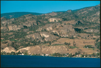
Skaha is a rock climbing area located near Penticton, BC, in the Okanagan Valley. It is generally pretty dry, making it a common destination for times of the year when Squamish is a little soggy. The VOC usually runs a trip there around Halloween. Skaha has climbs at all levels, in both the traditional and sport styles. There is also a lot of top-roping possibilities for beginners.
The club has some guidebooks for this area, including "Skaha Rockclimbs" by Howie Richardson.
Note that the old access from Brayside Farm has been closed, and a new access route should materialize soon now that the land has been purchased by the land conservancy of BC.
Directions

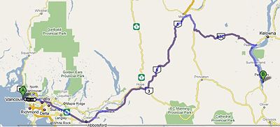
From Vancouver take the #1 east to Hope. At Hope, you have two options:
- Taking the #5 Coquihalla Highway, roughly 40 minutes faster than option below.
- Take #3 east towards Princeton and keep going past Princeton to Keremeos. At Keremeos take #3A north towards Pentiction, joining the #97 north for the final few kilometers along Skaha Lake into Penticton. Estimated time: 6 hours by the longer route.
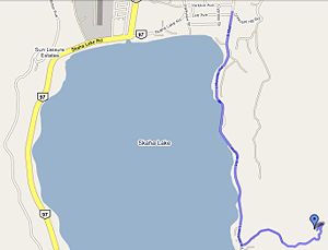
To access the new parking lot, drive as if you were going to the old Braesyde Farm parking lot, but instead of turning off South Main Road onto Crescent Hill Rd (the way to the now defunct Braesyde parking lot), continue south on South Main for 3.1 km. Here you will see Smythe Dr. on the left. The turn is near the crest of a slight rise & a blind corner. Take care making the left turn! When you reach the cul-de-sac at the end of Smythe Drive (350m from Lakeside Rd), continue straight ahead onto the gravel road of Painted Rock vineyard. Drive straight through a gravel intersection, through the open yellow gate until you are back on asphalt. The parking lot is at the end of this road.
Climbing

This is one of the best sport climbing destinations in BC and has lots to offer for trad, sport, and top roping. Here's a short list.
Beginner-friendly walls
- Fern Gully (5.6 to 5.9, don't know about top-rope access),
- Go Anywhere (5.7 to 5.9, with access for top-roping),
- Far Away (5.6 to 5.10b with access for top-roping),
- Red Tail Wall lower tier (large with 5.8 to 5.10a, most have access for top-roping)
- Another Buttress (large with 5.6 to 5.9, access for top-roping)
- Claim It All Wall (Mostly 5.10 sport, with 5.8 and 5.9 also, lots of routes)
- Doctor's Wall (Slighty overhanging wall, with 5.11+ sport)
- The Fortress (lots of climbs in 5.10-5.11 grade)
Fun Routes
- The Dream 5.9 gear (Redtail, The Turret)
- The Raven and the Bear 5.9 (5.10a in new guidebook) sport (Raven's Castle)
- Plum Line 5.9 sport (East Fortress)
- Ready to Strike 5.10a gear (Diamondback)
- Grassy Glades 5.10a gear (Grassy Glades)
- Assholes of August 5.9 gear (Red Tail Upper)
- Brilliant Pebbles 5.10c sport (Grassy Glades)
- Double Exposure 5.8 gear (East Portal)
Note: Sometimes it can rain when you are outside. If it does, there is a cave at Cave Hill to explore, but remember to bring a headlamp and helmet.