Archive:Mountaineering Camp/2007: Difference between revisions
imported>Bramvs m →Routes: typo |
imported>George No edit summary |
||
| (44 intermediate revisions by 13 users not shown) | |||
| Line 3: | Line 3: | ||
{{Main|Mountaineering Camp}} | {{Main|Mountaineering Camp}} | ||
''' | '''Labour Day Long Weekend'''<br> | ||
'''''September 1<sup>st</sup> - 3<sup>rd</sup>, 2007''''' | |||
==Pre-trip meeting== | |||
'''''Wednesday, August 29<sup>th</sup>, 6pm in clubroom''''' | |||
==FAQ== | ==FAQ== | ||
| Line 32: | Line 37: | ||
{{Main|Wedgemount Lake}} | {{Main|Wedgemount Lake}} | ||
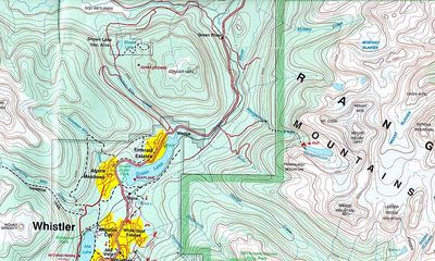
[[Image:Wedgemount_Lake_topo.jpg|thumb|right|400px|Topo map surrounding Wedgemount Lake]] | |||
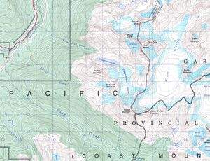
[[Image:92j2wedge.jpg|thumb|right|300px|Crop of NTS map suitable for printing]] | |||
[[Image:Wedgemount_Lake_topo.jpg|thumb| | |||
===Drive=== | ===Drive=== | ||
Follow the highway 99 North to Squamish and Whistler. Past Whistler, take the Wedgemount Lake Road turnoff. See [http://maps.google.com/maps?f=d&hl=en&geocode=&saddr=Vancouver,+BC&daddr=50.171667,-122.886667&sll=50.149406,-122.888947&sspn=0.083599,0.2314&ie=UTF8&z=8&om=1 google maps] for description untill here. This turnoff is on the right side of the road, after passing Green Lake. The [http://maps.google.com/maps/ms?ie=UTF8&hl=en&msa=0&msid=116090796283901305520.0004386091d9a41e3a09c&ll=50.170851,-122.874527&spn=0.020808,0.040169&t=h&z=15&om=1 Wedgemount Lake Road] can be driven with a normal 2WD (no low-riders tough ;-)). Turn left after crossing the Green River and railroad, then right up a hill where a sign indicates the route to Wedgemount Lake. Just a bit further up, the overgrown Rethel Creek Spur branches off to the right. Road's end is about 2km from Hwy 99 turnoff (parking and outhouse). | Follow the highway 99 North to Squamish and Whistler. Past Whistler, take the Wedgemount Lake Road turnoff. See [http://maps.google.com/maps?f=d&hl=en&geocode=&saddr=Vancouver,+BC&daddr=50.171667,-122.886667&sll=50.149406,-122.888947&sspn=0.083599,0.2314&ie=UTF8&z=8&om=1 google maps] for description untill here. This turnoff is on the right side of the road, after passing Green Lake. The [http://maps.google.com/maps/ms?ie=UTF8&hl=en&msa=0&msid=116090796283901305520.0004386091d9a41e3a09c&ll=50.170851,-122.874527&spn=0.020808,0.040169&t=h&z=15&om=1 Wedgemount Lake Road] can be driven with a normal 2WD (no low-riders tough ;-)). Turn left after crossing the Green River and railroad, then right up a hill where a sign indicates the route to Wedgemount Lake. Just a bit further up, the overgrown Rethel Creek Spur branches off to the right. Road's end is about 2km from Hwy 99 turnoff (parking and outhouse). Please don't leave tons of room in between the cars while parking, as the parking lot is likely going to get busy. | ||
===Approach=== | ===Approach=== | ||
| Line 80: | Line 50: | ||
===Camping spot=== | ===Camping spot=== | ||
We will all camp | We will all camp at the lake camp sites. These campsites are located at the North side of Wedgemount lake, ~10 minutes '''past''' the [http://www.bivouac.com/FtrPg.asp?FtrId=106 Wedgemount Lake hut], near the inlet from the Armchair Glacier. There are ~10 tentpads at this location with overflow camping available on the delta near the lake sites. There is also an outhouse and running creek for water at the lake camp sites. | ||
===Routes=== | ===Routes=== | ||
====Around Wedgemount Lake==== | |||
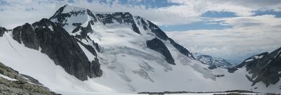
[[Image:Wedge_pan.jpg|thumb|400px|Left to right: Wedge, Parkhurst and Rethel Mountain (mid July '07)]] | [[Image:Wedge_pan.jpg|thumb|400px|Left to right: Wedge, Parkhurst and Rethel Mountain (mid July '07)]] | ||
| Line 90: | Line 62: | ||
'''Wedge Mountain (2892m)''' | '''Wedge Mountain (2892m)''' | ||
* West ridge, moderate scramble (*) from Wedgemount lake (can avoid glacier travel if needed) | * West ridge, moderate scramble (*) from Wedgemount lake (can avoid glacier travel if needed) | ||
* North ridge, glacier travel, up to | * North ridge, glacier travel, up to 45˚ snow/ice ridge (AD-) | ||
* Various couloirs on NE, N, NW side (might be snow or ice) | * Various couloirs on NE, N, NW side (might be snow or ice) | ||
| Line 97: | Line 69: | ||
* NW Ridge: Class 3-4 climb traversing all 3 summits of Mt. Weart from the Weart - Cook col. | * NW Ridge: Class 3-4 climb traversing all 3 summits of Mt. Weart from the Weart - Cook col. | ||
* North face: glacier travel, steep snow/ice face, possibly mixed (AD+) | * North face: glacier travel, steep snow/ice face, possibly mixed (AD+) | ||
'''Mount Cook (2676m)''' | |||
* Easy scramble (*) from Cook-Weart col (no glacier). | |||
* Easy scramble from the west ridge | |||
'''Mount Moe (2664m)''' | |||
* South ridge: scramble, glacier travel | |||
'''Parkhurst Mountain (2494m)''' | |||
* Moderate scramble (**) from Wedgemount lake (no glacier) | |||
'''Rethel Mountain (2408m)''' | |||
* Moderate scramble (**) from Rethel-Parkhurst col (no glacier) | |||
====East of Wedge-Weart col==== | |||
'''Lesser Wedge Mountain (2738m)''' | '''Lesser Wedge Mountain (2738m)''' | ||
* From the west: scramble from Wedge-Lesser Wedge col, glacier travel | * From the west: 4<sup>th</sup> class scramble from Wedge-Lesser Wedge col, glacier travel | ||
* Couloir on North side (might be snow, ice or mixed) | * Couloir on North side (might be snow, ice or mixed) | ||
| Line 106: | Line 93: | ||
* Snowy Owl Couloir on North side (might be snow, ice or mixed) | * Snowy Owl Couloir on North side (might be snow, ice or mixed) | ||
'''Mount James Turner (2703m)' | '''Mount James Turner (2703m)''' | ||
* Scramble from the southwest face and upper south ridge, glacier travel | * Scramble from the southwest face and upper south ridge, glacier travel | ||
* Scramble from the northwest ridge, glacier travel | * Scramble from the northwest ridge, glacier travel | ||
* Couloir on North side ( | * Couloir on North side (TD; snow ice, or mixed) | ||
''' | '''Peggy Peak (2623m)'''<br> | ||
''Unnamed "Peak 8600ft" NNE of Peggy Lake'' | |||
* Apparently an easy glacier walk from the North | |||
* | |||
'''Oasis Mountain (2561m)' | '''Oasis Mountain (2561m)''' | ||
* Easy from Eureka-Oasis col, involves glacier travel | * Easy from Eureka-Oasis col, involves glacier travel | ||
'''Eureka Mountain (2523m)' | '''Eureka Mountain (2523m)''' | ||
* Easy from Eureka-Oasis col, involves glacier travel | * Easy from Eureka-Oasis col, involves glacier travel | ||
===More information=== | ===More information=== | ||
| Line 135: | Line 113: | ||
* [http://www.elaho.ca/alpsel.htm Alpine Select]: Climbs in SW BC & N WA, Kevin McLane, 2001, Elaho publishing corporation. | * [http://www.elaho.ca/alpsel.htm Alpine Select]: Climbs in SW BC & N WA, Kevin McLane, 2001, Elaho publishing corporation. | ||
* [http://cairnpublishing.com/guidebooks/scrambles.htm Scrambles in SW BC], Matt Gunn, 2005, Cairn publishing. ''Difficulty (easy, moderate, | * [http://cairnpublishing.com/guidebooks/scrambles.htm Scrambles in SW BC], Matt Gunn, 2005, Cairn publishing. ''Difficulty (easy, moderate, difficult, very difficult) and quality (* to ***) ratings are given for scrambles in this area (see above).'' | ||
* A guide to climbing and hiking in SW BC, Bruce Fairley, 1986, Gordon Soules Book Publishers Ltd. | * A guide to climbing and hiking in SW BC, Bruce Fairley, 1986, Gordon Soules Book Publishers Ltd. | ||
* [http://www.bivouac.com/default.asp Bivouac] | * [http://www.bivouac.com/default.asp Bivouac] | ||
| Line 142: | Line 120: | ||
==Sign-up== | ==Sign-up== | ||
'''Pre-trip meeting: Wed. | '''''Note: Pre-trip meeting: Wed. August 29<sup>th</sup>, 6pm in clubroom''''' | ||
# Bram v.S. | # Bram v.S. | ||
| Line 152: | Line 130: | ||
# Scott Webster | # Scott Webster | ||
# Anne Webster | # Anne Webster | ||
# Marcin | # Marcin | ||
# Pascal Z | # Pascal Z | ||
# Jason B | # Jason B | ||
# Piotr F | # Piotr F | ||
# Henrik Nilsson (friend of Piotr's from Sweden) | # Henrik Nilsson (friend of Piotr's from Sweden) | ||
# Urszula Paleczek | # Urszula Paleczek | ||
# Dorota Paleczek | # Dorota Paleczek | ||
# Grant McGregor | |||
# Breakey | |||
# Charlie | |||
# Nasim | |||
# Matt Parisien | |||
# Miriam Barrueto | |||
# ... | # ... | ||
# '''You!''' | # '''You!''' | ||
| Line 168: | Line 150: | ||
Please write down your name, approximate area of departure, # of seats, approximate time of departure and return. | Please write down your name, approximate area of departure, # of seats, approximate time of departure and return. | ||
* | * '''Trusty Justy''', Point Grey, 3 (4 if needed; pack light, be prepared to squeeze) seats, leaving 1.30pm on Fri, returning to Vancouver late Monday night (or earlier if weather craps out) | ||
**< | # Lara | ||
# Bram | |||
** | # Thomas | ||
* '''Scott's Car'''. Oak + 19th. 4 people total. Leaving Friday morning, returning Sunday. | |||
# Scott Webster | |||
# Anne Webster | |||
* '''Breakey's truck'''. McDonald & 4<sup>th</sup>. 5 seats. Leave Friday @ 7pm. | |||
# Breakey | |||
# Charlie Caunt | |||
# Piotr F | |||
# Piotr's Friend | |||
# One last spot for someone. | |||
* '''Jason's car''' 3 spots. | |||
# Jason B | |||
# Urszula Paleczek | |||
# Dorota Paleczek | |||
* '''Evan's "truck"'''. Leaving from Boundary Saturday morning | |||
# Evan (if possible would like to find a spare seat somewhere instead of driving. Might also be able to get a 4 seat car) | |||
# Christian Champagne | |||
# Pascal | |||
==Food and tent groups== | ==Food and tent groups== | ||
The easiest thing is for people in the same car to sort out food and tent groups. | The easiest thing is for people in the same car to sort out food and tent groups. | ||
'''Food Group # 1''' | |||
* Evans Morris | |||
* Pascal Z. | |||
* Christian Champagne | |||
[[Category:Mountaineering Trips]] | [[Category:Mountaineering Trips]] | ||
[[Category:Mountaineering Camp]] | |||
Latest revision as of 20:27, 20 October 2019
VOC Mountaineering Camp 2007
Labour Day Long Weekend
September 1st - 3rd, 2007
Pre-trip meeting
Wednesday, August 29th, 6pm in clubroom
FAQ
What is it?
It's an opportunity for VOCers of different abilities to get together and enjoy some scrambling/mountaineering together. Although we will all camp in one spot, different groups will head out to different destinations during the day. The evenings will be filled with good food, good stories, and good times.
This is not an instructional trip (do not confuse it with Glacier school). Although there will likely be experienced members around who may be willing to give you some advice.
When is it?
It will be held on Labour Day long weekend (September 1st - 3rd). It is possible that some people will drive/hike up on Friday August 31st.
Where is it?
The camp will be held at Wedgemount lake. This is located just North of Whistler, on the East side of the Sea to Sky highway. The relevant mapsheet is 92J/02. You can download this mapsheet for free here (29MB).
Who's in charge?
Bram is organizing stuff. See the member's list for contact information. Trip will be organised using a combination of the VOC forum, this wiki page, and a pre-trip meeting (Wed. 29, 6pm, clubroom).
Is it for me/you?
This year's camp will hopefully have something for (almost) everyone. The destination is accessible enough for beginners but exotic enough to be interesting to the mountain hard-person.
Drive, approach, routes


Drive
Follow the highway 99 North to Squamish and Whistler. Past Whistler, take the Wedgemount Lake Road turnoff. See google maps for description untill here. This turnoff is on the right side of the road, after passing Green Lake. The Wedgemount Lake Road can be driven with a normal 2WD (no low-riders tough ;-)). Turn left after crossing the Green River and railroad, then right up a hill where a sign indicates the route to Wedgemount Lake. Just a bit further up, the overgrown Rethel Creek Spur branches off to the right. Road's end is about 2km from Hwy 99 turnoff (parking and outhouse). Please don't leave tons of room in between the cars while parking, as the parking lot is likely going to get busy.
Approach
Follow the Wedgemount Lake Trail (1150m elevation gain in ~7km), steep but easy to follow.
Camping spot
We will all camp at the lake camp sites. These campsites are located at the North side of Wedgemount lake, ~10 minutes past the Wedgemount Lake hut, near the inlet from the Armchair Glacier. There are ~10 tentpads at this location with overflow camping available on the delta near the lake sites. There is also an outhouse and running creek for water at the lake camp sites.
Routes
Around Wedgemount Lake


Wedge Mountain (2892m)
- West ridge, moderate scramble (*) from Wedgemount lake (can avoid glacier travel if needed)
- North ridge, glacier travel, up to 45˚ snow/ice ridge (AD-)
- Various couloirs on NE, N, NW side (might be snow or ice)
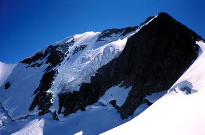
Weart Mountain (2822m)
- Southeast ridge: moderate scramble (***) from Wedgemount lake (no glacier)
- NW Ridge: Class 3-4 climb traversing all 3 summits of Mt. Weart from the Weart - Cook col.
- North face: glacier travel, steep snow/ice face, possibly mixed (AD+)
Mount Cook (2676m)
- Easy scramble (*) from Cook-Weart col (no glacier).
- Easy scramble from the west ridge
Mount Moe (2664m)
- South ridge: scramble, glacier travel
Parkhurst Mountain (2494m)
- Moderate scramble (**) from Wedgemount lake (no glacier)
Rethel Mountain (2408m)
- Moderate scramble (**) from Rethel-Parkhurst col (no glacier)
East of Wedge-Weart col
Lesser Wedge Mountain (2738m)
- From the west: 4th class scramble from Wedge-Lesser Wedge col, glacier travel
- Couloir on North side (might be snow, ice or mixed)
The Owls (2720m)
- From the south: apparently easy, steep and loose
- Snowy Owl Couloir on North side (might be snow, ice or mixed)
Mount James Turner (2703m)
- Scramble from the southwest face and upper south ridge, glacier travel
- Scramble from the northwest ridge, glacier travel
- Couloir on North side (TD; snow ice, or mixed)
Peggy Peak (2623m)
Unnamed "Peak 8600ft" NNE of Peggy Lake
- Apparently an easy glacier walk from the North
Oasis Mountain (2561m)
- Easy from Eureka-Oasis col, involves glacier travel
Eureka Mountain (2523m)
- Easy from Eureka-Oasis col, involves glacier travel
More information
Note that all books are available from the VOC library, please copy and bring them back asap so other people can use them too.
- Alpine Select: Climbs in SW BC & N WA, Kevin McLane, 2001, Elaho publishing corporation.
- Scrambles in SW BC, Matt Gunn, 2005, Cairn publishing. Difficulty (easy, moderate, difficult, very difficult) and quality (* to ***) ratings are given for scrambles in this area (see above).
- A guide to climbing and hiking in SW BC, Bruce Fairley, 1986, Gordon Soules Book Publishers Ltd.
- Bivouac
- Cascade Climbers
Sign-up
Note: Pre-trip meeting: Wed. August 29th, 6pm in clubroom
- Bram v.S.
- Lara T.
- Thomas B.
- Evan M.
- Matthieu S.
- Christian C.
- Scott Webster
- Anne Webster
- Marcin
- Pascal Z
- Jason B
- Piotr F
- Henrik Nilsson (friend of Piotr's from Sweden)
- Urszula Paleczek
- Dorota Paleczek
- Grant McGregor
- Breakey
- Charlie
- Nasim
- Matt Parisien
- Miriam Barrueto
- ...
- You!
Rides
Please write down your name, approximate area of departure, # of seats, approximate time of departure and return.
- Trusty Justy, Point Grey, 3 (4 if needed; pack light, be prepared to squeeze) seats, leaving 1.30pm on Fri, returning to Vancouver late Monday night (or earlier if weather craps out)
- Lara
- Bram
- Thomas
- Scott's Car. Oak + 19th. 4 people total. Leaving Friday morning, returning Sunday.
- Scott Webster
- Anne Webster
- Breakey's truck. McDonald & 4th. 5 seats. Leave Friday @ 7pm.
- Breakey
- Charlie Caunt
- Piotr F
- Piotr's Friend
- One last spot for someone.
- Jason's car 3 spots.
- Jason B
- Urszula Paleczek
- Dorota Paleczek
- Evan's "truck". Leaving from Boundary Saturday morning
- Evan (if possible would like to find a spare seat somewhere instead of driving. Might also be able to get a 4 seat car)
- Christian Champagne
- Pascal
Food and tent groups
The easiest thing is for people in the same car to sort out food and tent groups.
Food Group # 1
- Evans Morris
- Pascal Z.
- Christian Champagne