Mamquam: Difference between revisions
imported>Hairycow No edit summary |
imported>ScottN No edit summary |
||
| Line 1: | Line 1: | ||
[[Using This Ski Guide]] | [[Using This Ski Guide]] | ||
{{ski guide sidebar|img=mamquam.gif}} | |||
==Route at a Glance== | ==Route at a Glance== | ||
Revision as of 17:08, 30 January 2008
Route at a Glance
| Rating | Map Refs | Road | Route | Start Elevation | High Point | Technical Notes |
| Advanced | 92G/15 | <22km/?hrs | 6km/4hrs | 990m | 2580m | Strenuous day/Overnight, Glacier Travel |
Access
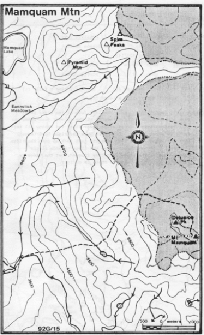
Head off Mamquam road (0km); left at Indian Arm spur 3.7km left fork 6.7km; left fork 9.5km; left fork over bridge (mile post 9) 12.7km; right over bridge 12.9km; left 13.2km; sharp left 15.1km; left (mile post 11) at 15.9 km; left 17.3km right just after pond 21.4km; park near junction at 22.1km, or by creek just beyond. This road is not plowed in the winter.
Route
Cross the creek on a logging road bridge and head NE through the forest (staying on the left of the creek). Continue NE when the creek swings SE; and then up to a ridge (1680m) above a minor lake east of Mamquam. Drop down to the lake and head up an obvious gully which exits at the edge of the ice-field. Skirt Delusion Peak (aptly named) to Mamquam behind. It is possible to ski to within a few meters of the summit.
Hazards
- Possible avalanche and falling ice on approach to icefields.
- The glacier is heavily crevassed.
- Creeks dangerously high in late spring
