Tenquille Lake: Difference between revisions
Jump to navigation
Jump to search
imported>Hairycow No edit summary |
imported>Matthew |
||
| (3 intermediate revisions by 2 users not shown) | |||
| Line 1: | Line 1: | ||
{{ski guide old}} | |||
[[Using This Ski Guide]] | [[Using This Ski Guide]] | ||
| Line 16: | Line 17: | ||
|- | |- | ||
| Intermediate | | Intermediate | ||
| | | {{NTS link|092|j|07}}, {{NTS link|092|j|10}} | ||
| | | few meters | ||
| 10km/5hrs | | 10km/5hrs | ||
| 240m | | 240m | ||
| Line 30: | Line 31: | ||
==Route== | ==Route== | ||
Follow the trail straight up through woods to an old logging road. The trail follows this for a while then traverses up Wolverine Creek, and then across an old rock slide. A little | Follow the trail straight up through woods to an old logging road. The trail follows this for a while then traverses up Wolverine Creek, and then across an old rock slide. A little searching may be required to find the markers on the other side; they are slightly uphill of the entry point. The route follows the right hand side of Wolverine Creek up to the pass and then down to the head of the lake. The [[Tenquille Lake Cabin]] is located just inside the trees by the lake. The cabin may be buried in snow, but the chimney can usually be spotted. | ||
==Hazards== | ==Hazards== | ||
Latest revision as of 23:33, 20 February 2008

|
Out of Date |
| This article contains old out of date information from an early 1990s edition of the VOC Ski guide. Road conditions may have changed considerably since this article was written. |

Route at a Glance
| Rating | Map Refs | Road | Route | Start Elevation | High Point | Technical Notes |
| Intermediate | 92 J/7, 92 J/10 | few meters | 10km/5hrs | 240m | 1720m | 2-3 Days, Cabin, Copper Mound:2160m |
Access
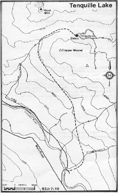
Park near the Lillooet River bridge and take an old road to the right on the north side of the bridge. The trail begins a few meters up the road on the left.
Route
Follow the trail straight up through woods to an old logging road. The trail follows this for a while then traverses up Wolverine Creek, and then across an old rock slide. A little searching may be required to find the markers on the other side; they are slightly uphill of the entry point. The route follows the right hand side of Wolverine Creek up to the pass and then down to the head of the lake. The Tenquille Lake Cabin is located just inside the trees by the lake. The cabin may be buried in snow, but the chimney can usually be spotted.
Hazards
- Avalanche hazard above tree line and on trail below Copper Mound.