Mount Slesse: Difference between revisions
Jump to navigation
Jump to search
imported>George Created page with "{{Mountainbox | Name=Mount Slesse | BivouacMtnID=1207 | Photo=Mount Slesse.jpg | Caption=Northwest aspect of Sleese Mountain in winter. | Region=Fraser Valley-Manning | Elevat..." |
imported>George No edit summary |
||
| Line 9: | Line 9: | ||
| Coordinates (NAD 27)={{coord|10U|602586|5431048|NAD27|hidedatum}} | | Coordinates (NAD 27)={{coord|10U|602586|5431048|NAD27|hidedatum}} | ||
| NTS Topographic map={{NTS link|092|H|04}} | | NTS Topographic map={{NTS link|092|H|04}} | ||
| QuickInfo= | | QuickInfo=A steep prominent peak known for the crash of a plane into the east face killing all 62 on board. | ||
}}__NOTOC__ | }}__NOTOC__ | ||
Latest revision as of 06:10, 4 January 2019
| Mount Slesse | Region | Fraser Valley-Manning |
|---|---|---|
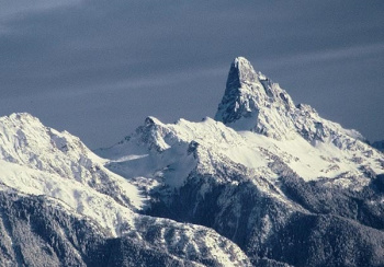
 Northwest aspect of Sleese Mountain in winter. |
Elevation | 2429 m (7969 ft) |
| Coordinates |
| |
| Quick Info | A steep prominent peak known for the crash of a plane into the east face killing all 62 on board. |