Brew Hut: Difference between revisions
imported>PaigeFM |
imported>Josephchiao |
||
| (139 intermediate revisions by 38 users not shown) | |||
| Line 1: | Line 1: | ||
{{Hutbox | |||
| Name=Brew Hut | |||
| Photo=NewBrewMostlyDone.jpg | |||
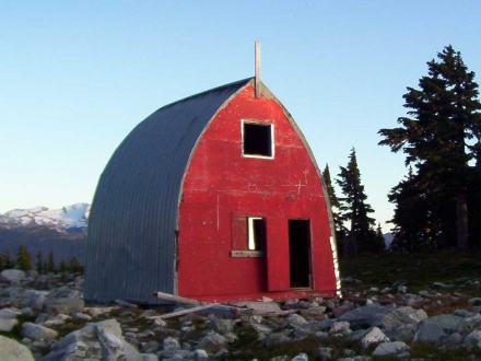
| Caption=Brew Hut III nearing completion | |||
| Elevation=1686m (5530ft) | |||
| Coordinates (WGS 84)={{coord|10U|486305|5543098|WGS84|hidedatum}} | |||
| Coordinates (NAD 27)={{coord|10U|486404|5542900|NAD27|hidedatum}} | |||
| NTS Topographic map={{NTS link|092|J|03}} | |||
| VOC Fee=$15/night | |||
| Reservations=No | |||
| Locked=No | |||
| Access=[[Roe-Brew Trail]] | |||
| Built=2005 | |||
| Caretaker=Varsity Outdoor Club | |||
| Capacity=12-16 | |||
| Legal Type=License of Occupation Tenure | |||
| Legal Number=[[Media:2012_Brew_Tenure.pdf|242022]] | |||
| Legal Status=Active until 2042-06-08 | |||
| BivouacFeatureID=114 | |||
}} | |||
The (2005) '''Brew Hut''' is located at a high col just south of Mt. Brew (as the name appears on NTS mapsheets). It sleeps about 12 people comfortably, but has been known to [[Media:brew_packing.pdf|sleep up to 19]] if you get really cozy. The hut is very well insulated and has a wood stove. | |||
Please use firewood very sparingly. In 2014 we spent about $6500 to helicopter wood in. Other years we've spent similar amounts. | |||
[https://huts.ubc-voc.com/Brew/ Brew Hut on VOC Huts website] | |||
{{ | {{NoCampfires|alignment=center}} | ||
<br> | |||
== | ==History== | ||
{{main|Construction of Brew Hut I, II and III}} | |||
The first incarnation, Brew Hut 1, was built by the Varsity Outdoor Club in 1982 at the outlet of a small lake. This location was unsuitable, and the hut was destroyed by snow creep the first year. It was taken apart and helicoptered to its second location and rebuilt in 1984, atop a ridge above the lake. Some pieces were damaged, so Brew Hut II was slightly shorter than the original. It was expected that the ridge location would protect the Hut from snow damage but snow accumulated at the new location to an alarming degree because of a line of trees acting as a snow fence beside the hut. The exact location of Brew Hut 2 was 486784E 5542749N (UTM Zone 10N, NAD27) at 1650m elevation. | |||
Brew 2 was rumoured to be lost for a number of years. Nobody seemed to know exactly where it was. Winter ski trips to the area were not able to find the hut. Heavy snow burying the hut and confusing terrain in the area are the suspected causes. It was only the rise of GPS technology that really allowed Brew Hut 2 to become accessible again. | |||
Brew 2 was damaged during the winter of 1998-1999. In the Spring of 1999 (the high-snow year) snow depth was two metres over the roof top, and though the hut was found, it was too much work to dig down to use it. When it finally melted out it was found to be a bit crushed by the snow, but still useable. A new location with much less snow accumulation was identified later that summer, a few hundred meters west of the present hut. Snow depths at this new location have been monitored over a few winters and it has been shown to accumulate much less snow. | |||
In the fall of 2002 (?) a work party went in with the intention of dismantling the hut, but ended up just making modifications, reinforcing some of the cracked beams on the upper floor. Some scrap material from around the hut was moved to the new hut site, and a small structure was erected to further test the effect a structure would have on wind transport at this site. This structure was named micro-brew in light of its diminutive size and the popularity of Granville Island Pale Ale among the builders. | |||
The | In april 2003, a party visited the area, finding the brew hut buried up to the top of the roof. The hut was located only by the 2x4 pole sticking out of the snow. Nearby, the micro-brew structure was relatively snow free, and still easily visible despite being only 1/4 as tall as the Brew Hut. | ||
In the spring and summer of 2005, Brew Hut 3 was constructed. Foundation work started in May, and construction carried on through the summer and into the fall. Brew 2 was dismantled in September 2005 for firewood after the new hut was finished. In late summer and early fall 2006, the outhouse was erected and a woodshed was constructed from the remains of Brew Hut 2. See the [[Brew Hut Rebuild]] page for more details. Since 2006, renovations on the hut have kept it in good condition. In 2017 the VOC, with the support of the UBC Sustainability Fund, installed a small solar panel that can now power a single LED light via a one-hour timer switch. In 2018, a new outhouse with an above ground solid storage unit and a mechanical unit that separates solids and liquids was constructed just west of the old site with the old outhouse superstructure being reused. [https://www.ubc-voc.com/2018/09/26/brew-outhouse-and-door-project-part-1-design-preconstruction Read the 3 part trip report here]. A new commercial polystyrene insulated door and accessories were also installed. | |||
==Fees and Current Conditions== | |||
[[File:Roecreekpalletbridge.jpg|link=http://www.ubc-voc.com/wiki/File:Roecreekpalletbridge.jpg|thumb|Dec 25th - Temporary Roe Creek Foot Bridge on the left]]{{about huts in general}} | |||
'''Nov 2020 Update:''' Bridge across Roe Creek was removed on Oct 26th. You can no longer drive the road to the R200 turnoff. Creek can be more than a meter deep after a lot of precipitation. The VOC is looking into options for a foot bridge. | |||
'''March 2022 Update:''' Bridge is back over Roe Creek! | |||
== | ==Access== | ||
{{ | {{main|Roe-Brew Trail}} | ||
{{main|Roe Creek Road}} | |||
The primary access to Brew Hut in winter and summer is via the [[Roe-Brew Trail]]. The zoning around Brew Hut is currently unresolved with no clear indication for demarcation in foreseeable future (as of 2018). The area has historically been non-motorized and local heli-guiding and cat-ski companies have respected this historical precedence. The VOC would like to kindly remind visitors that the hut is intended for non-motorized users only. Air access to the Hut is explicitly for hut work related trips (such as providing firewood or renovation materials) and not permitted for any other purpose. For further details on recreation zoning see the page on [[Winter Recreation Zoning near VOC Huts]] and the latest VOC [[Hut Maintenance#Hut Management Plans|Hut Management Plan]]. | |||
By any access route, the final alpine section before reaching Brew Hut is an off trail hike (or ski). Whiteouts conditions are common above Brew Lake, making good [[navigation]] skills necessary to reach the hut. A map ({{NTS link|092|j|03}}) and compass are essential to have along. Alternatively to the Roe-Brew Trail, one can access the hut by the [[Brew Lake Trail]], however it is longer and in winter is less straightforward. For full details on trails in the Brew Area see the [[Brew Area Trails]] page. | |||
The following topographical map shows the Roe-Brew Trail with logging roads current to October 2013: | |||
* [http://www.ubc-voc.com/mediawiki/images/1/13/Brew_access_october_2013.pdf 1:50,000 Brew Access Map (PDF File, BC TRIM data)] | |||
== | ==Facilities== | ||
The information on this page is just a snapshot. See the [[Hut Inventory]] Page for complete information on tools and materials at the Hut. The upstairs loft sleeps about 10 comfortably ([[Media:brew_packing.pdf|16 maximum]]), and 3 more can sleep on the extra wide bench downstairs. | |||
There are | {{HutFacilities | ||
| Heating=Wood Stove (Use sparingly!) | |||
| Lighting=Solar LED Lighting | |||
| Fire Safety=Two Fire Extinguisers | |||
| First Aid=Spine Board | |||
| Sleeping=Loft and downstairs benches. No sleeping pads. | |||
| Capacity=16 (record is 22 set in October 2016) | |||
| Drinking Water=Pond or Snow from West side of Hut | |||
| Human Waste= Outhouse just NE of the Hut | |||
| Grey Water=Discard to the East side of the Hut | |||
| Garbage= Pack it out! | |||
}} <!--Use the <br> tag if you wish to use more than one line break in one section--> | |||
=== Water === | |||
There are seasonal ponds E and W of the hut: please only get drinking water from the pond that is on the west side, since the outhouse is on the east side. The west pond also tends to hold its water later into the year because of a large snow drift above it. In heavy snow years, this snow drift can cover the pond completely well into late summer or fall. In winter please keep the snow on the west side of the hut clean for drinking water and dispose of grey water to the east side of the hut towards the outhouse. This will keep the drinking water supply as clean as possible for all guests year round. Note in early October 2011 the west pond was still frozen and had ~ 2m of snow atop the ice. But you can always find snow to melt for water. | |||
=== | === Heating and Lighting === | ||
A newly installed solar light should work for about 8 hours if its battery is fully charged. Turn it on for an hour with the black button, and turn it off manually with the red button. It shuts off automatically after about an hour. | |||
There is a wood stove provided, '''for winter use only'''. Please be conservative, as the wood supply must last the winter. In the summer, spring and fall, the cooking stoves provide more than enough heat, as the entire hut is insulated with R20 fiberglass. Firewood is stacked in the wood shed outside. Don't cut down any live trees for firewood; they are very slow growing and don't burn well either. Ashes from the stove go in the metal paint can with no label. | |||
{{NoCampfires|alignment=left}} | |||
The | <span style="color:red">Please use firewood sparingly. The VOC spent about $7K to fly in 4 cords of firewood in 2014 and it lasted only 2 years. '''This is not the place to make campfires.'''</span> Unless the wind is howling, the snow is flying, and you are actually cold, don't light the wood-burning heater. If you're a strong party consider carrying up your own firewood. The VOC over the past two years have dedicated an annual workhike named "How many VOCers does it take to replace a Helicopter". This is a two day one night workhike on the weekend in June immediately before the Canada Day Long Weekend (for 2018 this will be June 23rd and June 24th). If you use the Hut and would like to help us stock up the cabin with firewood on this trip sign-up on our trip agenda or send us an email at information(at)ubc-voc(dot)com | ||
In high snow years the woodshed can be hard to find as it gets buried in a massive snow wall. Starting from the mid point between the two windows on your right as you enter the hut, take the perpendicular for ~4.5m (you can use your probe to measure). This should get you to the closest corner of the shed. Now use your probe to probe for the hut - try probing a bit farther than that so that you don't miss it. | |||
==== Firewood Hauling Log ==== | |||
{| class="wikitable" | |||
!Date | |||
!Transport | |||
!Cost | |||
!Amount of Firewood | |||
!Trip Report | |||
|- | |||
|2012 September | |||
|Human | |||
|''<small>200</small>'' | |||
|1/2 an old rotten log | |||
|[https://www.ubc-voc.com/phorum5/read.php?3,88012,88659#msg-88659 Link] | |||
|- | |||
|2014 July | |||
|Helicopter | |||
|7,000 | |||
|4 cords / 10,000 lbs | |||
|[https://www.ubc-voc.com/tripagenda/details.php?tripid=765 Link] | |||
|- | |||
|2016 June | |||
|Human | |||
|''<small>500</small>'' | |||
|50 rounds / 600 lbs | |||
|[https://www.ubc-voc.com/2016/06/28/hauling-firewood Link] | |||
|- | |||
|2017 August | |||
|Human | |||
|''<small>300</small>'' | |||
|40 rounds / 500 lbs | |||
|[https://www.ubc-voc.com/phorum5/read.php?3,123472,123799#msg-123799 Link] | |||
|- | |||
|2018 July | |||
|Human | |||
|''<small>400</small>'' | |||
|50 rounds / 600 lbs | |||
|[https://www.ubc-voc.com/phorum5/read.php?3,127029,127349#msg-127349 Link] | |||
|- | |||
|2018 September | |||
|Helicopter | |||
|1,400 | |||
|1 cord / 2,400 lbs | |||
|[https://www.ubc-voc.com/2018/09/26/brew-outhouse-and-door-project-part-2-helicopter-foundation Link] | |||
|- | |||
|2022 October | |||
|Helicopter | |||
| | |||
| | |||
| | |||
|} | |||
=== Outhouse === | |||
In September of 2018 a new outhouse was constructed north of the hut. The outhouse is unique in that all solid waste is collected in an above ground storage unit and that it uses a solids-liquids separator to better allow solids within the storage unit can dry out and decompose. [https://www.ubc-voc.com/2018/09/26/brew-outhouse-and-door-project-part-1-design-preconstruction To read more about the project view the 3-part trip report here.] | |||
=== | === Games and Music === | ||
There is a guitar up at the hut in very good condition however the case is broken and flimsy and needs replacing. There are numerous decks of cards, one of which is likely complete. | |||
=== Library === | |||
A small library is provided for the enjoyment of hut users: | |||
* VOC Journals: '''[[VOC_Journal#List_of_publications|List of VOC Journals at this Hut]]''' | |||
* [[VOC Songbook]] (1 new, 1 old) | |||
* Into Thin Air by Jon Krakauer | |||
* the Giant Book of Card Games | |||
==Winter Activities== | |||
===Skiing=== | |||
{{avalanche hazard}} | |||
The area around Mount Brew receives huge amounts of snow in the winter - perhaps as much as 50% more than nearby Whistler mountain. This makes it an excellent destination when fresh snow is scarce, and a good place to stay away from during poor weather. If the Whistler / Squamish weather forecast is for a few flurries, the weather at Brew will probably be a whiteout with constant snow and wind. There are some good ski slopes nearby, varying from mellow to death defying. A high alpine ridge connects this area to Cypress Peak and Mount Fee to the west. | |||
The area around Brew | |||
<small> | |||
:;Around Brew Lake: There are big open mellow slopes on the North and West sides of Brew Lake. West of the lake is very mellow, a good area for beginner skiers. The north end of the lake has some moderately steep south facing slopes with sparse trees that are a good place to ski in bad weather. Usually this area is reached by skiing back along the usual route from Brew Lake. There are also some steep chutes that drop directly into this area from the hut. | |||
:;West Side: There are two bowls on the west side of the ridge that divides Roe Creek from Brew Lake. Westside Bowl faces W and has some nice moderate runs with just enough trees to keep the visibility in check in poor weather. Sunflower bowl is a bit further north, and faces generally SW. The gladed south facing slopes on the skier's right side of the bowl are a nice place to hang out on a cold day. Getting into sunflower bowl can be tricky due to cornices at the top on the skier's left side. The easiest approach is from the bottom of westside bowl, or from the col with Brandywine Creek. | |||
:;Into Brandywine Creek: An 1100ft ski run drops NW from the door of the hut down to a small lake in Brandywine Creek. This is an awesome run when it's in condition, but it is threatened by very steep slopes off the skiers left side that avalanche frequently. There are good safe zones to stop partway down the run, but the bottom of the run is an avalanche runout zone. The best climb back up is a longer loop around to the west that uses a natural bench system to avoid exposure to steep avalanche start zones. This run can be a bit of a wind funnel, even down low where it seems to be protected. | |||
' | ::The bowl to the west of the cabin (Brandywine Bowl) has some very nice lines that go down into brandywine creek and hit the bench mentioned above. There's a lot of skiing in this bowl on N, NE and E aspects. The run off the top of the 1800m summit on the west side of the bowl is particularly good. Be mindful of the big cornices and wind loading when skiing here. This area is a bit more protected from wind and less committing than the front door run, but is still very much avalanche prone. | ||
:;East of the Hut: A short run east from the hut goes down to yet another small lake. Continuing down east of the lake there is good tree skiing run (Shady Trees) down to a flat bench at 1300m, which makes for a nice long run with views of the valley. Be careful not to get sucked into a big gully on skier's left. From the bench, climb back up the tree run or make a rising traverse south to reach the eastern edge of Brew Lake. | |||
::With good stability, climb the peak East of Mt. Brew where there is good skiing on the north side. The usual route to this peak requires crossing some steep slopes above the "gully of death," and is only recommended with good stability. The southeast side of this peak has tree skiing the goes down into the same area as the the Shady Trees run mentioned above. | |||
</small> | |||
===Powder Mountain Catskiing=== | |||
[[Image:monstervan.jpg|thumb|right|400px| Monstrous Powder Mountain Van.]] | |||
[http://www.powdermountaincatskiing.com Powder Mountain Catskiing] operates a cat skiing operation out of chance creek on the south side of Tricouni. They now also have a tenure for driving their cats up the Roe Creek logging road and skiing off the slopes east of Cypress Peak. These slopes are only a few kilometers from the Brew Hut. PMC has agreed to take their clients elsewhere while parties are at the Brew hut (and during the 5 previous days) given 2 weeks advance notice. Be sure to give them a call before going to the Brew Hut in winter to make sure they don't bother you. Also, if skiing in to the hut via the Roe Creek route, PMC may have plowed the Chance Creek FSR, or compressed the snow so much that it's driveable - be sure to ask them about parking and snow conditions. Contact information is provided below. | |||
*Email: [http://powdermountaincatskiing.com/contact-us/ main@powdermountaincatskiing.com] | |||
==Summer Activities== | |||
===Hiking=== | |||
The area around Brew Lake has some beautiful heather meadows. An alpine ridge connects the Mt. Brew area with the Squamish-Cheakamus divide to the west. The divide can be traversed south towards [[Tricouni Meadows]] or north past Mt. Fee to [[Brandywine Mountain]] and Brandywine Meadows (otherwise known as the [[Alcoholic Traverse]]) | |||
== | |||
The | |||
===Swimming=== | |||
Brew Lake is very shallow, and the shoreline is mostly very muddy. The best spot for swimming is where the summer hiking trail comes up from Brandywine Falls, just east of the outlet. The lake is a lot deeper here, and there are some rocks that make getting in and out more pleasant | |||
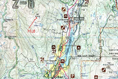
==Maps== | |||
* [http://caltopo.com/m/0S0F Caltopo Map of the Winter Route] based on waypoints from VOC Wiki, information from ClubTread and recorded GPS data from a 2013 Trip | |||
* [https://caltopo.com/m/0MPCF Caltopo Map of some skiing options] based on various sources so use with caution. | |||
The following topographical map shows the Roe Creek access trail with logging roads current to October 2013: | |||
* [http://www.ubc-voc.com/mediawiki/images/1/13/Brew_access_october_2013.pdf 1:50,000 Brew Access Map (PDF File, BC TRIM data)] | |||
==Gallery== | |||
Note: Topo Map shows the location of the new hut. | Note: Topo Map shows the location of the new hut. | ||
<gallery mode="packed" heights="220px"> | |||
File:BrewMap.gif|Topo of Mt. Brew Area, Map: 92 J/3 | |||
File:Brew-Hut.jpg|The old Brew Hut in the Summer (Brew 2) | |||
File:Brew04Bluff2.jpg|Brew Hut Roe Creek Trail Bluff #2 | |||
</gallery> | |||
==External Links== | |||
== | |||
[[Category:Huts]] | [[Category:Huts]] | ||
Latest revision as of 02:42, 24 August 2025
| Brew Hut | |
|---|---|
 Brew Hut III nearing completion | |
| Overnight Capacity | 12-16 |
| Coordinates |
|
| Elevation | 1686m (5530ft) |
| Fee | $15/night (PAY ONLINE HERE) |
| Reservations | No |
| Locked | No |
| Access | Roe-Brew Trail |
| Built | 2005 |
| Caretaker | Varsity Outdoor Club |
| Legal | |
The (2005) Brew Hut is located at a high col just south of Mt. Brew (as the name appears on NTS mapsheets). It sleeps about 12 people comfortably, but has been known to sleep up to 19 if you get really cozy. The hut is very well insulated and has a wood stove. Please use firewood very sparingly. In 2014 we spent about $6500 to helicopter wood in. Other years we've spent similar amounts.
| Campfires are PROHIBITED at all VOC huts. | |
| VOC Huts are located in sensitive alpine environments. Follow Leave No Trace principles and please do not make campfires.
If you see someone having a campfire at one of our huts, please report them to information(at)ubc-voc(dot).com. |
History
The first incarnation, Brew Hut 1, was built by the Varsity Outdoor Club in 1982 at the outlet of a small lake. This location was unsuitable, and the hut was destroyed by snow creep the first year. It was taken apart and helicoptered to its second location and rebuilt in 1984, atop a ridge above the lake. Some pieces were damaged, so Brew Hut II was slightly shorter than the original. It was expected that the ridge location would protect the Hut from snow damage but snow accumulated at the new location to an alarming degree because of a line of trees acting as a snow fence beside the hut. The exact location of Brew Hut 2 was 486784E 5542749N (UTM Zone 10N, NAD27) at 1650m elevation.
Brew 2 was rumoured to be lost for a number of years. Nobody seemed to know exactly where it was. Winter ski trips to the area were not able to find the hut. Heavy snow burying the hut and confusing terrain in the area are the suspected causes. It was only the rise of GPS technology that really allowed Brew Hut 2 to become accessible again.
Brew 2 was damaged during the winter of 1998-1999. In the Spring of 1999 (the high-snow year) snow depth was two metres over the roof top, and though the hut was found, it was too much work to dig down to use it. When it finally melted out it was found to be a bit crushed by the snow, but still useable. A new location with much less snow accumulation was identified later that summer, a few hundred meters west of the present hut. Snow depths at this new location have been monitored over a few winters and it has been shown to accumulate much less snow.
In the fall of 2002 (?) a work party went in with the intention of dismantling the hut, but ended up just making modifications, reinforcing some of the cracked beams on the upper floor. Some scrap material from around the hut was moved to the new hut site, and a small structure was erected to further test the effect a structure would have on wind transport at this site. This structure was named micro-brew in light of its diminutive size and the popularity of Granville Island Pale Ale among the builders.
In april 2003, a party visited the area, finding the brew hut buried up to the top of the roof. The hut was located only by the 2x4 pole sticking out of the snow. Nearby, the micro-brew structure was relatively snow free, and still easily visible despite being only 1/4 as tall as the Brew Hut.
In the spring and summer of 2005, Brew Hut 3 was constructed. Foundation work started in May, and construction carried on through the summer and into the fall. Brew 2 was dismantled in September 2005 for firewood after the new hut was finished. In late summer and early fall 2006, the outhouse was erected and a woodshed was constructed from the remains of Brew Hut 2. See the Brew Hut Rebuild page for more details. Since 2006, renovations on the hut have kept it in good condition. In 2017 the VOC, with the support of the UBC Sustainability Fund, installed a small solar panel that can now power a single LED light via a one-hour timer switch. In 2018, a new outhouse with an above ground solid storage unit and a mechanical unit that separates solids and liquids was constructed just west of the old site with the old outhouse superstructure being reused. Read the 3 part trip report here. A new commercial polystyrene insulated door and accessories were also installed.
Fees and Current Conditions

No reservations are taken, but please see the VOC Hut Registration page to help coordinate use.
For the most up to date information on the Hut see the Bulletins on the Hut Registration Page.
VOC huts are open to all non-motorized, non-commercial users. A $15 per person per night fee applies to pay for hut maintenance. The fee can be sent in to the VOC via our Showpass Donation Page or can be left at the hut in the blue drop box. If neither of these work, you can send it to the VOC by mail. VOC trips have priority during fall and winter holidays (New Years, Reading Week, Easter) so please contact the VOC before planning a trip during this time. Commercial groups are requested to contact the VOC before using any of the huts. There is a lost and found page for items in and around the VOC huts.
Nov 2020 Update: Bridge across Roe Creek was removed on Oct 26th. You can no longer drive the road to the R200 turnoff. Creek can be more than a meter deep after a lot of precipitation. The VOC is looking into options for a foot bridge.
March 2022 Update: Bridge is back over Roe Creek!
Access
The primary access to Brew Hut in winter and summer is via the Roe-Brew Trail. The zoning around Brew Hut is currently unresolved with no clear indication for demarcation in foreseeable future (as of 2018). The area has historically been non-motorized and local heli-guiding and cat-ski companies have respected this historical precedence. The VOC would like to kindly remind visitors that the hut is intended for non-motorized users only. Air access to the Hut is explicitly for hut work related trips (such as providing firewood or renovation materials) and not permitted for any other purpose. For further details on recreation zoning see the page on Winter Recreation Zoning near VOC Huts and the latest VOC Hut Management Plan.
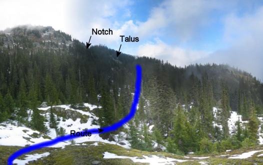
By any access route, the final alpine section before reaching Brew Hut is an off trail hike (or ski). Whiteouts conditions are common above Brew Lake, making good navigation skills necessary to reach the hut. A map (92 J/3) and compass are essential to have along. Alternatively to the Roe-Brew Trail, one can access the hut by the Brew Lake Trail, however it is longer and in winter is less straightforward. For full details on trails in the Brew Area see the Brew Area Trails page.
The following topographical map shows the Roe-Brew Trail with logging roads current to October 2013:
Facilities
The information on this page is just a snapshot. See the Hut Inventory Page for complete information on tools and materials at the Hut. The upstairs loft sleeps about 10 comfortably (16 maximum), and 3 more can sleep on the extra wide bench downstairs.
| Heating | Wood Stove (Use sparingly!) |
| Lighting | Solar LED Lighting |
| Cooking | |
| Fire Safety | Two Fire Extinguisers |
| First Aid | Spine Board |
| Sleeping | Loft and downstairs benches. No sleeping pads. |
| Capacity | 16 (record is 22 set in October 2016) |
| Drinking water | Pond or Snow from West side of Hut |
| Human Waste | Outhouse just NE of the Hut |
| Greywater | Discard to the East side of the Hut |
| Garbage | Pack it out! |
Water
There are seasonal ponds E and W of the hut: please only get drinking water from the pond that is on the west side, since the outhouse is on the east side. The west pond also tends to hold its water later into the year because of a large snow drift above it. In heavy snow years, this snow drift can cover the pond completely well into late summer or fall. In winter please keep the snow on the west side of the hut clean for drinking water and dispose of grey water to the east side of the hut towards the outhouse. This will keep the drinking water supply as clean as possible for all guests year round. Note in early October 2011 the west pond was still frozen and had ~ 2m of snow atop the ice. But you can always find snow to melt for water.
Heating and Lighting
A newly installed solar light should work for about 8 hours if its battery is fully charged. Turn it on for an hour with the black button, and turn it off manually with the red button. It shuts off automatically after about an hour.
There is a wood stove provided, for winter use only. Please be conservative, as the wood supply must last the winter. In the summer, spring and fall, the cooking stoves provide more than enough heat, as the entire hut is insulated with R20 fiberglass. Firewood is stacked in the wood shed outside. Don't cut down any live trees for firewood; they are very slow growing and don't burn well either. Ashes from the stove go in the metal paint can with no label.
| Campfires are PROHIBITED at all VOC huts. | |
| VOC Huts are located in sensitive alpine environments. Follow Leave No Trace principles and please do not make campfires.
If you see someone having a campfire at one of our huts, please report them to information(at)ubc-voc(dot).com. |
Please use firewood sparingly. The VOC spent about $7K to fly in 4 cords of firewood in 2014 and it lasted only 2 years. This is not the place to make campfires. Unless the wind is howling, the snow is flying, and you are actually cold, don't light the wood-burning heater. If you're a strong party consider carrying up your own firewood. The VOC over the past two years have dedicated an annual workhike named "How many VOCers does it take to replace a Helicopter". This is a two day one night workhike on the weekend in June immediately before the Canada Day Long Weekend (for 2018 this will be June 23rd and June 24th). If you use the Hut and would like to help us stock up the cabin with firewood on this trip sign-up on our trip agenda or send us an email at information(at)ubc-voc(dot)com
In high snow years the woodshed can be hard to find as it gets buried in a massive snow wall. Starting from the mid point between the two windows on your right as you enter the hut, take the perpendicular for ~4.5m (you can use your probe to measure). This should get you to the closest corner of the shed. Now use your probe to probe for the hut - try probing a bit farther than that so that you don't miss it.
Firewood Hauling Log
| Date | Transport | Cost | Amount of Firewood | Trip Report |
|---|---|---|---|---|
| 2012 September | Human | 200 | 1/2 an old rotten log | Link |
| 2014 July | Helicopter | 7,000 | 4 cords / 10,000 lbs | Link |
| 2016 June | Human | 500 | 50 rounds / 600 lbs | Link |
| 2017 August | Human | 300 | 40 rounds / 500 lbs | Link |
| 2018 July | Human | 400 | 50 rounds / 600 lbs | Link |
| 2018 September | Helicopter | 1,400 | 1 cord / 2,400 lbs | Link |
| 2022 October | Helicopter |
Outhouse
In September of 2018 a new outhouse was constructed north of the hut. The outhouse is unique in that all solid waste is collected in an above ground storage unit and that it uses a solids-liquids separator to better allow solids within the storage unit can dry out and decompose. To read more about the project view the 3-part trip report here.
Games and Music
There is a guitar up at the hut in very good condition however the case is broken and flimsy and needs replacing. There are numerous decks of cards, one of which is likely complete.
Library
A small library is provided for the enjoyment of hut users:
- VOC Journals: List of VOC Journals at this Hut
- VOC Songbook (1 new, 1 old)
- Into Thin Air by Jon Krakauer
- the Giant Book of Card Games
Winter Activities
Skiing
| Avalanche Hazard | |
| The route and terrain described here is capable of producing avalanches. Safe travel requires the skills and equipment to assess and mitigate avalanche hazards. A professionally taught training course is highly recommended. |
The area around Mount Brew receives huge amounts of snow in the winter - perhaps as much as 50% more than nearby Whistler mountain. This makes it an excellent destination when fresh snow is scarce, and a good place to stay away from during poor weather. If the Whistler / Squamish weather forecast is for a few flurries, the weather at Brew will probably be a whiteout with constant snow and wind. There are some good ski slopes nearby, varying from mellow to death defying. A high alpine ridge connects this area to Cypress Peak and Mount Fee to the west.
- Around Brew Lake
- There are big open mellow slopes on the North and West sides of Brew Lake. West of the lake is very mellow, a good area for beginner skiers. The north end of the lake has some moderately steep south facing slopes with sparse trees that are a good place to ski in bad weather. Usually this area is reached by skiing back along the usual route from Brew Lake. There are also some steep chutes that drop directly into this area from the hut.
- West Side
- There are two bowls on the west side of the ridge that divides Roe Creek from Brew Lake. Westside Bowl faces W and has some nice moderate runs with just enough trees to keep the visibility in check in poor weather. Sunflower bowl is a bit further north, and faces generally SW. The gladed south facing slopes on the skier's right side of the bowl are a nice place to hang out on a cold day. Getting into sunflower bowl can be tricky due to cornices at the top on the skier's left side. The easiest approach is from the bottom of westside bowl, or from the col with Brandywine Creek.
- Into Brandywine Creek
- An 1100ft ski run drops NW from the door of the hut down to a small lake in Brandywine Creek. This is an awesome run when it's in condition, but it is threatened by very steep slopes off the skiers left side that avalanche frequently. There are good safe zones to stop partway down the run, but the bottom of the run is an avalanche runout zone. The best climb back up is a longer loop around to the west that uses a natural bench system to avoid exposure to steep avalanche start zones. This run can be a bit of a wind funnel, even down low where it seems to be protected.
- The bowl to the west of the cabin (Brandywine Bowl) has some very nice lines that go down into brandywine creek and hit the bench mentioned above. There's a lot of skiing in this bowl on N, NE and E aspects. The run off the top of the 1800m summit on the west side of the bowl is particularly good. Be mindful of the big cornices and wind loading when skiing here. This area is a bit more protected from wind and less committing than the front door run, but is still very much avalanche prone.
- East of the Hut
- A short run east from the hut goes down to yet another small lake. Continuing down east of the lake there is good tree skiing run (Shady Trees) down to a flat bench at 1300m, which makes for a nice long run with views of the valley. Be careful not to get sucked into a big gully on skier's left. From the bench, climb back up the tree run or make a rising traverse south to reach the eastern edge of Brew Lake.
- With good stability, climb the peak East of Mt. Brew where there is good skiing on the north side. The usual route to this peak requires crossing some steep slopes above the "gully of death," and is only recommended with good stability. The southeast side of this peak has tree skiing the goes down into the same area as the the Shady Trees run mentioned above.
Powder Mountain Catskiing

Powder Mountain Catskiing operates a cat skiing operation out of chance creek on the south side of Tricouni. They now also have a tenure for driving their cats up the Roe Creek logging road and skiing off the slopes east of Cypress Peak. These slopes are only a few kilometers from the Brew Hut. PMC has agreed to take their clients elsewhere while parties are at the Brew hut (and during the 5 previous days) given 2 weeks advance notice. Be sure to give them a call before going to the Brew Hut in winter to make sure they don't bother you. Also, if skiing in to the hut via the Roe Creek route, PMC may have plowed the Chance Creek FSR, or compressed the snow so much that it's driveable - be sure to ask them about parking and snow conditions. Contact information is provided below.
Summer Activities
Hiking
The area around Brew Lake has some beautiful heather meadows. An alpine ridge connects the Mt. Brew area with the Squamish-Cheakamus divide to the west. The divide can be traversed south towards Tricouni Meadows or north past Mt. Fee to Brandywine Mountain and Brandywine Meadows (otherwise known as the Alcoholic Traverse)
Swimming
Brew Lake is very shallow, and the shoreline is mostly very muddy. The best spot for swimming is where the summer hiking trail comes up from Brandywine Falls, just east of the outlet. The lake is a lot deeper here, and there are some rocks that make getting in and out more pleasant
Maps
- Caltopo Map of the Winter Route based on waypoints from VOC Wiki, information from ClubTread and recorded GPS data from a 2013 Trip
- Caltopo Map of some skiing options based on various sources so use with caution.
The following topographical map shows the Roe Creek access trail with logging roads current to October 2013:
Gallery
Note: Topo Map shows the location of the new hut.
-
 Topo of Mt. Brew Area, Map: 92 J/3
 -
 The old Brew Hut in the Summer (Brew 2)
 -
 Brew Hut Roe Creek Trail Bluff #2


