Omer lakes: Difference between revisions
Jump to navigation
Jump to search
imported>Hairycow No edit summary |
imported>Hairycow No edit summary |
||
| Line 1: | Line 1: | ||
==Route at a Glance== | ==Route at a Glance== | ||
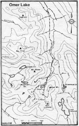
[[image:Omerlake.gif|thumb|Topo of Loch Lomond]] | |||
{| border="1" cellpadding="3" cellspacing="0" | {| border="1" cellpadding="3" cellspacing="0" | ||
|- align="center" style="background-color: #cccccc;" | |- align="center" style="background-color: #cccccc;" | ||
| Rating | | Rating | ||
| Location Key | | Location Key | ||
| Line 12: | Line 14: | ||
| High Point | | High Point | ||
| Technical Notes | | Technical Notes | ||
|- | |- | ||
| | | Intermediate | ||
| | | C | ||
| 92G/ | | 92G/11E | ||
| | | 4km/2hrs | ||
| | | 2km/2hrs | ||
| | | 580m | ||
| | | 1310m | ||
| | | | ||
|} | |} | ||
==Access== | ==Access== | ||
Same as Loch Lomond | |||
==Route== | ==Route== | ||
From the starting point for the Loch Lomond trip, contour to the right until Omer Creek is reached. Stay to right of the creek and follow it into an open bowl below Red Mountain. Cross the creek and traverse up to the trees below cliffs and left of the bowl. From the trees traverse up to a notch at the top of the bowl. From the trees traverse up to a notch at the top of the bowl. Omer Lake is just beyond. To continue beyond the lake, it is easier to stay on the left side. Mt. Sheer and the Mountain Lake Cabin are also accessible from here. | |||
==Hazards== | ==Hazards== | ||
# Avalanches and falling ice in the bowl just below Omer Lake. | |||
# Thin ice on lakes in late spring. | |||
==Trail Conditions== | ==Trail Conditions== | ||
Revision as of 04:10, 29 January 2008
Route at a Glance

| Rating | Location Key | Map Refs | Road | Route | Start Elevation | High Point | Technical Notes |
| Intermediate | C | 92G/11E | 4km/2hrs | 2km/2hrs | 580m | 1310m |
Access
Same as Loch Lomond
Route
From the starting point for the Loch Lomond trip, contour to the right until Omer Creek is reached. Stay to right of the creek and follow it into an open bowl below Red Mountain. Cross the creek and traverse up to the trees below cliffs and left of the bowl. From the trees traverse up to a notch at the top of the bowl. From the trees traverse up to a notch at the top of the bowl. Omer Lake is just beyond. To continue beyond the lake, it is easier to stay on the left side. Mt. Sheer and the Mountain Lake Cabin are also accessible from here.
Hazards
- Avalanches and falling ice in the bowl just below Omer Lake.
- Thin ice on lakes in late spring.