Black Tusk Meadows: Difference between revisions
imported>ScottN |
imported>ScottN implemented use of ski guide sidebar |
||
| Line 1: | Line 1: | ||
{{ski guide sidebar|ntsmap={{NTS link|092|g|14}}|img=blacktusk.gif|difficulty=Intermediate|start=410m or 610m if the road is driveable|high=Black Tusk Meadows: 1650m East knob: 2100m|note=Day trip, Shelter in Taylor meadows|road=<3km/<30mins|trail=7.5km/3hrs to Taylor Meadows}} | |||
{| | |||
| | |||
| | |||
| 410m or 610m if the road is driveable | |||
| Black Tusk Meadows: 1650m East knob: 2100m | |||
| Day trip, Shelter in Taylor meadows | |||
|} | |||
==Access== | ==Access== | ||
Revision as of 18:58, 28 February 2008
| ||||||||||||||
| ||||||||||||||
 | ||||||||||||||
Access
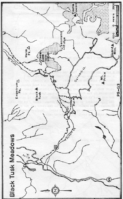
The Rubble Creek turnoff for the Garibaldi Lake Trail is located about midway between Squamish and Whistler (Google Map), about 250km return. There is a prominent sign, Garibaldi - Black Tusk trailhead, indicating the turnoff. The road leads about 2km to the parking lot at approximately 600m elevation. Only the first 400m of this road is normally plowed in winter, up to a private driveway. Do not block access to this private driveway when parking along the road.
Route
From the parking lot a well maintained trail switch-backs up the slope beside Rubble Creek. At 6km is a sign posted junction; take the left fork to Taylor Meadows and Black Tusk Meadows (right for Garibaldi Lake). The trail is poorly marked after entering the meadows, but not too difficult to follow. Ski eastward to reach the picnic shelter, campground and outhouses at Taylor Meadows. The upper meadows, Panorama Ridge and Black Tusk may be reached by continuing to the east. These objectives are strenuous day trips from the car.
Ski runs
Black tusk meadows is 2km past Taylor Meadows. There is a large prominent clearing, above which are several excellent ski runs of up to 450m vertical drop. The summit of the east knob is a good objective when approached from it's SW side. There are also good several ski runs on similar slopes a little farther east.
Panorama Ridge has attractive ski terrain on it's north side. It's a little farther away than the east knob, so is more suitable as an overnight trip.
Hazards
- Avalanches. ATES ratings given by the Canadian Avalanche Association are "Simple" for the trail to Taylor Meadows, "Challenging" for Black Tusk Meadows and Panorama Ridge and "Complex" for the steep slopes below the Black Tusk.