Rethel Creek: Difference between revisions
Jump to navigation
Jump to search
imported>Hairycow No edit summary |
imported>Hairycow No edit summary |
||
| Line 1: | Line 1: | ||
[[Using This Ski Guide]] | [[Using This Ski Guide]] | ||
| Line 9: | Line 8: | ||
|- align="center" style="background-color: #cccccc;" | |- align="center" style="background-color: #cccccc;" | ||
| Rating | | Rating | ||
| Map Refs | | Map Refs | ||
| Road | | Road | ||
| Line 17: | Line 15: | ||
| Technical Notes | | Technical Notes | ||
|- | |- | ||
| | | Advanced | ||
| | | 92J/2 | ||
| | | 7km/3hrs | ||
| | | 4km/3hrs | ||
| | | 640m | ||
| | | 2130m | ||
| | | Overnight, cabin, Wedge Mnt:2900 | ||
|} | |} | ||
==Access== | ==Access== | ||
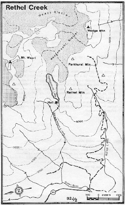
About 2km north of Green Lake on the east side of highway 99, a railway bridge and a logging road both cross the Green River. Usually this road is snowed in and wehicles must be parked on the shoulder of the highway. | |||
==Route== | ==Route== | ||
Follow the logging road across the Green River, then take the major right hand forks which lead to about 1200m on Rethel Creek. Follow the creek to an open, flat area just west of the Wedge-Parkhurst col, where good campsites abound. From here Wedge or Parkhurst Col, can be scrambled up, or ski tours made over the col towards Mount Weart or Eureka. | |||
==Hazards== | ==Hazards== | ||
# | # Some avalanche hazard between upper Rethel Creek and the col. | ||
# Crevasses on Wedgemount and Weart Glacier | |||
==Trail Conditions== | ==Trail Conditions== | ||
Revision as of 05:22, 31 January 2008

Route at a Glance
| Rating | Map Refs | Road | Route | Start Elevation | High Point | Technical Notes |
| Advanced | 92J/2 | 7km/3hrs | 4km/3hrs | 640m | 2130m | Overnight, cabin, Wedge Mnt:2900 |
Access
About 2km north of Green Lake on the east side of highway 99, a railway bridge and a logging road both cross the Green River. Usually this road is snowed in and wehicles must be parked on the shoulder of the highway.
Route
Follow the logging road across the Green River, then take the major right hand forks which lead to about 1200m on Rethel Creek. Follow the creek to an open, flat area just west of the Wedge-Parkhurst col, where good campsites abound. From here Wedge or Parkhurst Col, can be scrambled up, or ski tours made over the col towards Mount Weart or Eureka.
Hazards
- Some avalanche hazard between upper Rethel Creek and the col.
- Crevasses on Wedgemount and Weart Glacier