Brew waypoints: Difference between revisions
Jump to navigation
Jump to search
imported>Rolandburt |
imported>Rolandburt |
||
| Line 54: | Line 54: | ||
These posted so they can be loaded into a GPS..... | These posted so they can be loaded into a GPS..... | ||
<p> | <p> | ||
This is Roland's GPX file for finding Brew Hut [http://www.ubc-voc.com/mediawiki/images/8/83/BrewHut2011.gpx GPX file] | |||
<br> | |||
<br> | |||
The following WP coords are taken from this page as WGS84 UTM | The following WP coords are taken from this page as WGS84 UTM | ||
</p> | </p> | ||
#[http://bandster.ca/maps/gpx/brew.gpx GPX Tracks] | #[http://bandster.ca/maps/gpx/brew.gpx GPX Tracks] BROKEN LINK | ||
#[http://bandster.ca/maps/kml/brew.kml GoogleEarth] | #[http://bandster.ca/maps/kml/brew.kml GoogleEarth] BROKEN LINK | ||
#[http://maps.google.com/maps?q=http://bandster.ca/maps/kml/brew.kml GoogleMap] | #[http://maps.google.com/maps?q=http://bandster.ca/maps/kml/brew.kml GoogleMap] BROKEN LINK | ||
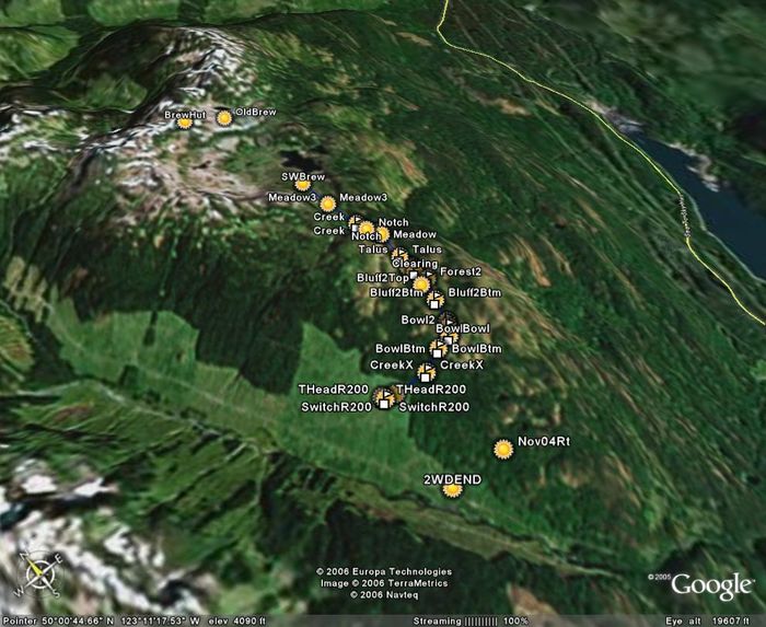
[[Image:BrewHutGoogleEarth.jpg|700px]] | [[Image:BrewHutGoogleEarth.jpg|700px]] | ||
Revision as of 03:24, 6 April 2012
Datum for all waypoints is WGS84. There are presented in order of usefulness.
Waypoints for Hut locations
- Brew Hut 486307E 5543101N
- Old Brew Hut site 486690E 5542951N
Waypoints for traveling between Brew Lake and the Brew Hut in poor weather
These waypoints (WGS - 84) have been tested in a complete whiteout. Taking a topographical map to accompany these waypoints is a good idea.
- 0486728E 5541925N - near SW corner of Brew Lake
- 0486424E 5542101N - climbing towards upper lake
- 0486165E 5542366N - upper lake
- 0486122E 5542786N - slopes above upper lake
- 0486124E 5543078N - col between Brew Lake and Brandywine Creek
- 0486213E 5543061N - highest gap in trees below Brew Hut. This waypoint is useful to avoid the wind lip that forms on the north side of the ridge in winter
- 0486307E 5543101N - Brew Hut
Waypoints for Roe creek ski route
Route as flagged
- Switchback on R200 486050E 5539444N
- Trailhead on R200, start of yellow flags 486038E 5539473N
- Enter Old Growth Forest 486147E 5539420N
- Just below creek crossing 486470E 5539388N
- Bottom of open bowl and junction with previous route (orange flags) 486706E 5539497N
- In bowl 486858E 5539523N
- In bowl #2 486901E 5539590N
- top of bowl 486932E 5539637N
- end of a small draw below bluff #2 487004E 5539875N
- Reenter forest after going below bluff #2 487112E 5540107N
- a clearing 487070E 5540244N
- Below bluff #3 487075E 5540310N
- bottom of Talus slope 487065E 5540459N
- start of meadow system 487076E 5540751N
- more meadows 487056E 5540790N
- notch joins from west 486983E 5540869N
- cross small creek to East side? 486955E 5540991N
- More meadows 486890E 5541371N
- End of yellow flagging at SW shore of Brew Lake 486851E 5541748N
Other meaningful Waypoints
- top of bluff #2 487000E 5540070N flagged route goes below
- top of bluff #3 487041E 5540312N flagged route goes below
- Bottom of November 2004 flagged route 486544E 5538492N
- end of 2wd on roe creek FSR 486042E 5538556N
- roe creek / chance creek FSR junction 487139E 5535135N (49.96842°N, 123.17933°W)
Waypoints for Brew Lake Trail
GPS Files for Waypoints
These posted so they can be loaded into a GPS.....
This is Roland's GPX file for finding Brew Hut GPX file
The following WP coords are taken from this page as WGS84 UTM
- GPX Tracks BROKEN LINK
- GoogleEarth BROKEN LINK
- GoogleMap BROKEN LINK
