Harrison Hut: Difference between revisions
imported>George |
imported>George |
||
| Line 38: | Line 38: | ||
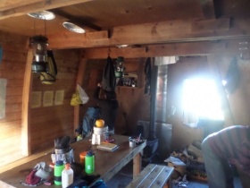
[[File:Harrison_Main_Floor.JPG|thumb|right|280px|Main Floor of Harrison Hut]] | [[File:Harrison_Main_Floor.JPG|thumb|right|280px|Main Floor of Harrison Hut]] | ||
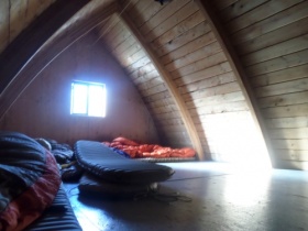
[[File:Harrison_Loft.JPG|thumb|right|280px|The loft can sleep about 15 people]] | [[File:Harrison_Loft.JPG|thumb|right|280px|The loft can sleep about 15 people]] | ||
{ | {{HutFacilities | ||
| | | Heating=Wood stove | ||
| | | Lighting=Two Coleman White Gas Lanterns | ||
| Cooking=Two Coleman White Gas Stove and One [[Propane Coleman Stove]] | |||
| | | Sleeping=Open floor loft. No pads. | ||
| Capacity=15 persons | |||
| | | Drinking Water=Nearby creek (boil or filter) | ||
| Human Waste=Outhouse (Use the Aluminum North Outhouse) | |||
| | | Grey Water=Downhill of hut | ||
| Garbage=Pack it out | |||
| | }} | ||
| | |||
| | |||
| | |||
The Hut can sleep 15 friendly people. It has a very efficient wood stove, and is surprisingly cozy and warm. Clothes and boots may be dried. Dead wood for fuel can be obtained from a small forest 50 m away; the use of the stove for the past 15 or so years does not seem to have damaged the forest. If you are using the hut during winter season (usually accessed by helicopter or snowmobile), please bring your own firewood. A [[Coleman Stoves|Coleman stove]] and a Coleman lamp are provided, but you have to bring your own fuel (white gas). There is an outhouse. Water may be obtained from a nearby creek. | The Hut can sleep 15 friendly people. It has a very efficient wood stove, and is surprisingly cozy and warm. Clothes and boots may be dried. Dead wood for fuel can be obtained from a small forest 50 m away; the use of the stove for the past 15 or so years does not seem to have damaged the forest. If you are using the hut during winter season (usually accessed by helicopter or snowmobile), please bring your own firewood. A [[Coleman Stoves|Coleman stove]] and a Coleman lamp are provided, but you have to bring your own fuel (white gas). There is an outhouse. Water may be obtained from a nearby creek. | ||
Revision as of 02:48, 27 December 2017
| Harrison Hut | |
|---|---|
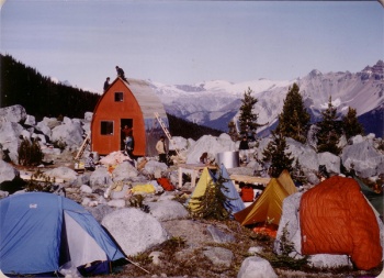
 Harrison Hut during construction | |
| Overnight Capacity | 15 |
| Coordinates |
|
| Elevation | 1725m |
| Fee | $10/night |
| Reservations | No |
| Locked | No |
| Built | 1983 |
| Caretaker | Varsity Outdoor Club |
| Legal | |
The Julian Harrison Hut is a large gothic A-frame located 50km north-west of Pemberton, BC at 1,725 m (5,659 ft). The Hut rests in a subalpine meadow at the northern most part of the Pemberton Icefield (south of Meager Creek valley), in the headwaters of Barr (a.k.a. Madhorse) Creek. Typical Access via the Meager Creek Valley is a 12.3km hike that starts at an elevation of 900m and traverses for 6km before beginning the final 825m of elevation gain. The total elevation gain on the trail is approximately 1200m due to the overall undulating nature of the trail. The Hut is currently maintained by the Varsity Outdoor Club of the AMS.
History
Initially called the Meager hut during the planning phase in 1983, the hut was renamed the Harrison Hut shortly after Julian Harrison (VOC President 1973-1974) was tragically killed in an avalanche in California in April of that year. The Hut was finally erected on the Thanksgiving weekend in the fall of 1983.
To read more about the construction of the Hut see the following transcription for the 23rd VOC Journal: Construction of Harrison Hut
Fees and Current Condition
No reservations are taken, but please see the VOC Hut Registration page to help coordinate use.
For the most up to date information on the Hut see the Bulletins on the Hut Registration Page.
VOC huts are open to all non-motorized, non-commercial users. A $15 per person per night fee applies to pay for hut maintenance. The fee can be sent in to the VOC via our Showpass Donation Page or can be left at the hut in the blue drop box. If neither of these work, you can send it to the VOC by mail. VOC trips have priority during fall and winter holidays (New Years, Reading Week, Easter) so please contact the VOC before planning a trip during this time. Commercial groups are requested to contact the VOC before using any of the huts. There is a lost and found page for items in and around the VOC huts.
For the most up to date information on the Hut see the Bulletin on the Hut Registration Page. Note that this is a bear-active area. Follow the proper bear aware procedures when hiking in this area.
Access
The hut is accessed via the Harrison Hut Trail.
Facilities


| Heating | Wood stove |
| Lighting | Two Coleman White Gas Lanterns |
| Cooking | Two Coleman White Gas Stove and One Propane Coleman Stove |
| Fire Safety | |
| First Aid | |
| Sleeping | Open floor loft. No pads. |
| Capacity | 15 persons |
| Drinking water | Nearby creek (boil or filter) |
| Human Waste | Outhouse (Use the Aluminum North Outhouse) |
| Greywater | Downhill of hut |
| Garbage | Pack it out |
The Hut can sleep 15 friendly people. It has a very efficient wood stove, and is surprisingly cozy and warm. Clothes and boots may be dried. Dead wood for fuel can be obtained from a small forest 50 m away; the use of the stove for the past 15 or so years does not seem to have damaged the forest. If you are using the hut during winter season (usually accessed by helicopter or snowmobile), please bring your own firewood. A Coleman stove and a Coleman lamp are provided, but you have to bring your own fuel (white gas). There is an outhouse. Water may be obtained from a nearby creek.
See the Hut Inventory Page for information on tools and materials at the Hut
Library
Updated October 18, 2017 by Elliott Skierszkan and George Hill
A collection of books are available at the Harrison Hut for your enjoyment.
- Edition Year # Copies
- VOCJ12: 1969-1970 x1
- VOCJ13: 1970-1971 x1
- VOCJ14: 1971-1972 x1
- VOCJ15: 1972-1973 x1
- VOCJ16: 1973-1974 x1
- VOCJ17: 1974-1975 x1
- VOCJ18: 1975-1976 x1
- VOCJ19: 1976-1977 x1
- VOCJ20: 1977-1978 x0
- VOCJ21: 1978-1979 x1
- VOCJ22: 1979-1980 x1
- VOCJ23: 1980-1981 x1
- VOCJ24: 1981-1982 x0
- VOCJ25: 1982-1983 x0
- VOCJ26: 1983-1984 x1
- VOCJ27: 1984-1985 x1
- VOCJ28: 1985-1986 x0
- VOCJ29: 1986-1987 x0
- VOCJ30: 1987-1988 x2
- VOCJ31: 1988-1989 x1
- VOCJ32: 1989-1990 x1
- VOCJ33: 1990-1991 x1
- VOCJ34: 1991-1992 x1
- VOCJ35: 1992-1993 x1
- VOCJ36: 1993-1994 x2
- VOCJ37: 1994-1995 x2
- VOCJ38: 1995-1996 x2
- VOCJ39: 1996-1997 x1
- VOCJ40: 1997-1998 x2
- VOCJ41: 1998-1999 x1
- VOCJ42: 1999-2000 x1
- VOCJ43: 2000-2001 x0
- VOCJ44: 2001-2002 x0
- VOCJ45: 2002-2003 x0
- VOCJ46: 2003-2004 x0
- VOCJ47: 2004-2005 x0
- VOCJ48: 2005-2006 x0
- VOCJ49: 2006-2007 x0
- VOCJ50: 2007-2008 x2
- VOCJ51: 2008-2009 x1
- VOCJ52: 2009-2010 x1
- VOCJ53: 2010-2011 x2
- VOCJ54: 2011-2012 x2
- VOCJ55: 2012-2013 x2
- VOCJ56: 2013-2014 x2
- VOCJ57: 2014-2015 x0
- VOCJ58: 2015-2016 x0
- VOCJ59: 2016-2017 x1
- VOCJ60: 2017-2018 x0
- VOCJ61: 2018-2019 x0
- VOCJ62: 2019-2020 x0
Activities

Winter
There are several glaciers within easy ski access from the Hut, and several peaks are nearby, offering suitable destinations for day trips. The Harrison hut is often used as the start or end point of the Pemberton Icefield Ski Traverse
Summer
There are several possibilities for hiking, scrambling and mountaineering in the area. The most popular routes are on Overseer Mountain, Frozen boot, and the Three Stooges.
Frozen Boot (Mount Breshnev)
- The North Ridge is a nice scramble. Mostly hiking with a few class 2-3 steps.
- The South Ridge is also a class 2-3 scramble, accessed from the col at the top of the Roller Coaster Glacier.
Overseer
Overseer is the highest summit on the Pemberton Icefield. There are two routes to get to the mountain from the hut. The first option is to ascend to the top of the Roller Coaster Glacier, cross over to the Madhorse Glacier and descend towards Overseer. The other option is to cross the north ridge of Frozen Boot (steep grassy slopes) and come up along the Madhorse Glacier.
- The South Ridge is a moderately difficult scramble with some loose rock. The rock is better on the ridge crest, but the climbing is more difficult (up to class 3). Difficulties can be avoided (at first on the left, then on the right), but the rock gets much worse away from the ridge.
Maps
- Harrison Hut Trail and Surrounding Area Map
- (notated) google map
- Media:Harrison_access_legal_size.pdf
GPX Tracks
External Links
- UBC Chronicles Archives (pdf file) mentioning the death of Julian Harrison (Fall 1983, p.14)
- American Alpine Club accident Report on Julian Harrison's death
Gallery
Add your photos!