Mamquam: Difference between revisions
imported>Hairycow No edit summary |
imported>Hairycow No edit summary |
||
| Line 1: | Line 1: | ||
==Route at a Glance== | ==Route at a Glance== | ||
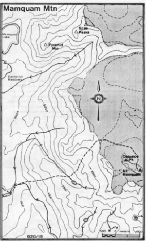
[[Image:mamquam.gif|thumb|Topo of Area]] | |||
{| border="1" cellpadding="3" cellspacing="0" | {| border="1" cellpadding="3" cellspacing="0" | ||
|- align="center" style="background-color: #cccccc;" | |- align="center" style="background-color: #cccccc;" | ||
| Rating | | Rating | ||
| Location Key | | Location Key | ||
| Line 13: | Line 14: | ||
| Technical Notes | | Technical Notes | ||
|- | |- | ||
| | | Advanced | ||
| | | C | ||
| 92G/ | | 92G/15 | ||
| | | <22km/?hrs | ||
| | | 6km/4hrs | ||
| | | 990m | ||
| | | 2580m | ||
| | | Strenuous day/Overnight, Glacier Travel | ||
|} | |} | ||
==Access== | ==Access== | ||
Head off Mamquam road (0km); left at Indian Arm spur 3.7km left fork 6.7km; left fork 9.5km; left fork over bridge (mile post 9) 12.7km; right over bridge 12.9km; left 13.2km; sharp left 15.1km; left (mile post 11) at 15.9 km; left 17.3km right just after pond 21.4km; park near junction at 22.1km, or by creek just beyond. This road is not plowed in the winter. | |||
==Route== | ==Route== | ||
Cross the creek on a logging road bridge and head NE through the forest (staying on the left of the creek). Continue NE when the creek swings SE; and then up to a ridge (1680m) above a minor lake east of Mamquam. Drop down to the lake and head up an obvious gully which exits at the edge of the ice-field. Skirt Delusion Peak (aptly named) to Mamquam behind. It is possible to ski to within a few meters of the summit. | |||
==Hazards== | ==Hazards== | ||
# Possible avalanche and falling ice on approach to icefields. | |||
# The glacier is heavily crevassed. | |||
# Creeks dangerously high in late spring | |||
{{avalanche hazard}} | {{avalanche hazard}} | ||
Revision as of 04:38, 29 January 2008
Route at a Glance

| Rating | Location Key | Map Refs | Road | Route | Start Elevation | High Point | Technical Notes |
| Advanced | C | 92G/15 | <22km/?hrs | 6km/4hrs | 990m | 2580m | Strenuous day/Overnight, Glacier Travel |
Access
Head off Mamquam road (0km); left at Indian Arm spur 3.7km left fork 6.7km; left fork 9.5km; left fork over bridge (mile post 9) 12.7km; right over bridge 12.9km; left 13.2km; sharp left 15.1km; left (mile post 11) at 15.9 km; left 17.3km right just after pond 21.4km; park near junction at 22.1km, or by creek just beyond. This road is not plowed in the winter.
Route
Cross the creek on a logging road bridge and head NE through the forest (staying on the left of the creek). Continue NE when the creek swings SE; and then up to a ridge (1680m) above a minor lake east of Mamquam. Drop down to the lake and head up an obvious gully which exits at the edge of the ice-field. Skirt Delusion Peak (aptly named) to Mamquam behind. It is possible to ski to within a few meters of the summit.
Hazards
- Possible avalanche and falling ice on approach to icefields.
- The glacier is heavily crevassed.
- Creeks dangerously high in late spring
| Avalanche Hazard | |
| The route and terrain described here is capable of producing avalanches. Safe travel requires the skills and equipment to assess and mitigate avalanche hazards. A professionally taught training course is highly recommended. |