Brohm Ridge: Difference between revisions
imported>Hairycow No edit summary |
imported>Bramvs →Access: Updated from looking at maps.gov.bc.ca and trip in summer. I've never done this route in winter. |
||
| Line 26: | Line 26: | ||
==Access== | ==Access== | ||
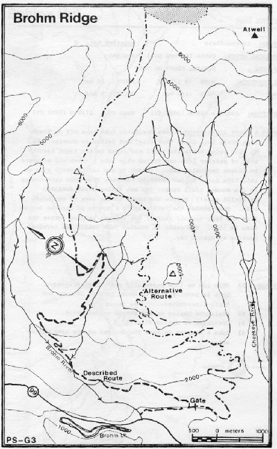
Follow Highway 99 North from Squamish, turn right on the Cheekye FSR before Brohm Lake. Take the first major road left (Brohm River FSR). Follow this road for several kilometers in a Northerly direction. Ignore two minor spurs on the left around the Km6 mark. Here the roads also switchbacks to a Southerly direction (eventually the road rejoins the Cheekye FSR a couple of kilometers before a gate). For the route described here, take a left spur around Km7.4 (Brohm Ridge Branch). This junction is around 1005m in elevation. Follow this spur road for about two kilometers to the end, ignoring a minor spur on the right in a switchback. The road takes you to a maximum elevation of about 1320m. | |||
An alternative route follows the Cheekye FSR all the way to a gate (1130m). The road continues to the [http://www.btsc.ca/ Black Tusk Snowmobile Club] chalet. The road ends at around 1720m on Brohm Ridge. Expect a lot of snowmobile traffic in winter. | |||
==Route== | ==Route== | ||
Revision as of 21:19, 20 February 2008

Route at a Glance
| Rating | Map Refs | Road | Route | Start Elevation | High Point | Technical Notes |
| Beginner | 92G/14E | <7km/<2hrs | 6km/2hrs | 640m | 1800m | Day trip, Designated snowmobile area, end of road 1250m |
Access
Follow Highway 99 North from Squamish, turn right on the Cheekye FSR before Brohm Lake. Take the first major road left (Brohm River FSR). Follow this road for several kilometers in a Northerly direction. Ignore two minor spurs on the left around the Km6 mark. Here the roads also switchbacks to a Southerly direction (eventually the road rejoins the Cheekye FSR a couple of kilometers before a gate). For the route described here, take a left spur around Km7.4 (Brohm Ridge Branch). This junction is around 1005m in elevation. Follow this spur road for about two kilometers to the end, ignoring a minor spur on the right in a switchback. The road takes you to a maximum elevation of about 1320m.
An alternative route follows the Cheekye FSR all the way to a gate (1130m). The road continues to the Black Tusk Snowmobile Club chalet. The road ends at around 1720m on Brohm Ridge. Expect a lot of snowmobile traffic in winter.
Route
The route on the ridge is partially flagged, but the ridge is sufficiently well defined not to present any route finding difficulties
Hazards
- Snowmobiles