Cloudburst Mountain: Difference between revisions
Jump to navigation
Jump to search
imported>Hairycow No edit summary |
imported>Hairycow No edit summary |
||
| Line 8: | Line 8: | ||
|- align="center" style="background-color: #cccccc;" | |- align="center" style="background-color: #cccccc;" | ||
| Rating | | Rating | ||
| Map Refs | | Map Refs | ||
| Road | | Road | ||
| Line 16: | Line 15: | ||
| Technical Notes | | Technical Notes | ||
|- | |- | ||
| | | Intermediate | ||
| 92G/ | | 92G/14 | ||
| | | 7km/3.5hrs | ||
| | | 5km/4.5hrs | ||
| | | 90m | ||
| | | 1870m | ||
| | | Long day/Overnight | ||
|} | |} | ||
==Access== | ==Access== | ||
Turn onto Squamish River Road from highway 99 (0km). Take the Squamish River Road for 26km to a branch just past the Weldwood Workyard. Branch road BR-100 begins here and depending on the snow level, this road can sometimes be driven to about 900m. | |||
==Route== | ==Route== | ||
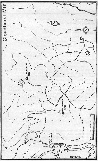
Ski BR-100 to the Microwave station on a small knoll at 900m then head up through a mature forest, staying to the left of the first cliffs. Ascend the steep forested slope just before a prominent rockslide and then take the SW ridge to the summit. Good campsites can be found at or just below the treeline. | |||
==Hazards== | ==Hazards== | ||
# | # Some steep slopes off summit ridges; however, these can be avoided | ||
==Trail Conditions== | ==Trail Conditions== | ||
Revision as of 05:29, 31 January 2008

Route at a Glance
| Rating | Map Refs | Road | Route | Start Elevation | High Point | Technical Notes |
| Intermediate | 92G/14 | 7km/3.5hrs | 5km/4.5hrs | 90m | 1870m | Long day/Overnight |
Access
Turn onto Squamish River Road from highway 99 (0km). Take the Squamish River Road for 26km to a branch just past the Weldwood Workyard. Branch road BR-100 begins here and depending on the snow level, this road can sometimes be driven to about 900m.
Route
Ski BR-100 to the Microwave station on a small knoll at 900m then head up through a mature forest, staying to the left of the first cliffs. Ascend the steep forested slope just before a prominent rockslide and then take the SW ridge to the summit. Good campsites can be found at or just below the treeline.
Hazards
- Some steep slopes off summit ridges; however, these can be avoided