Lizzie Lake: Difference between revisions
Jump to navigation
Jump to search
imported>Hairycow No edit summary |
imported>Hairycow No edit summary |
||
| Line 30: | Line 30: | ||
==Route== | ==Route== | ||
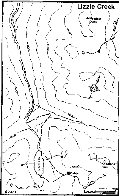
Contour around the NE shore of the lake, and then make a long rising traverse through a steep area to a hanging valley above the SE end of the lake. Pass through a narrow gorge at the outlet of the hanging valley. The | Contour around the NE shore of the lake, and then make a long rising traverse through a steep area to a hanging valley above the SE end of the lake. Pass through a narrow gorge at the outlet of the hanging valley. The [[Lizzie Lake Cabin]] is a short distance up the valley. | ||
==Hazards== | ==Hazards== | ||
Revision as of 05:15, 31 January 2008

Route at a Glance
| Rating | Map Refs | Road | Route | Start Elevation | High Point | Technical Notes |
| Intermediate | 92J/1 | <10km/<3hrs | 5km/3hrs | 640m | 1590m | Cabin |
Access
From the road on the east side of Lillooet Lake (plowed in winter) follow the Lizzie Creek road (unplowed) SE. As it steadily gains altitude it turns southward, then makes several long switch-backs and ends about 100m from Lizzie Lake (the road up the east fork of Lizzie Creek gives direct access to the Stein Divide).
Route
Contour around the NE shore of the lake, and then make a long rising traverse through a steep area to a hanging valley above the SE end of the lake. Pass through a narrow gorge at the outlet of the hanging valley. The Lizzie Lake Cabin is a short distance up the valley.