Harrison Hut Trail: Difference between revisions
imported>George Created page with "thumb|right|280px|Harrison Hut Route Sketch The hut can be reached via the Lillooet South FSR (aka [https://bivouac.com//RoadxPg.asp?RoadxId=6033 O..." |
imported>George No edit summary |
||
| Line 1: | Line 1: | ||
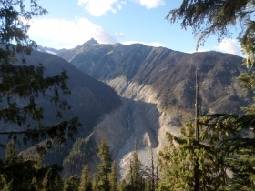
[[File:Harrison_Valley.JPG|thumb|right|380px|Hiking North-East towards the trailhead and the Capricorn Lookout]] | |||
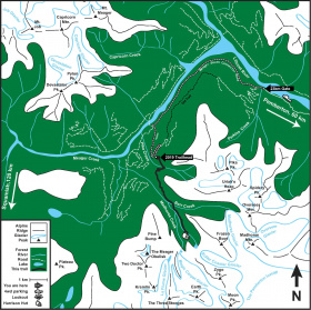
The Harrison Hut Trail is a 13.7km trail that links Harrison Hut to the Lillooet South FSR. For non-motorized parties completing the Pemberton Icefield Traverse this trail acts as the northern entrance (or exit). The trail travels through old growth, second growth, old cut blocks, fresh cut blocks, and old logging roads with a few viewpoints of the Meager and Capricorn Valley's along the first half of the trail. There are three creek crossings, the second of which has a steel bridge (Barr Creek). | |||
==Landslide Hazards== | |||
[[File:Harrison_Capricorn.JPG|thumb|right|280px|At Capricorn Lookout. In 2010 an entire side of the Capricorn Valley failed and causing the damage visible from this vantage ]] | |||
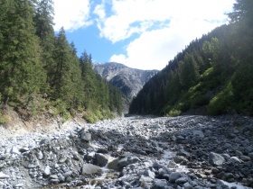
[[File:Harrison_Pika_Creek.JPG|thumb|right|280px|Hiking North-East towards the trailhead and the Capricorn Lookout]] | |||
The Meager Group is one of the most geologically active areas in Canada and is responsible for periodic landslides including, in 2010, one of the largest in Canadian recorded history. So, before heading up to the hut, you may wish to [[http://www.for.gov.bc.ca/dsq/engineering/roadinformation.htm check and see]] if the road/area has been closed. This sometimes happens during very hot periods where snow-melt increases, or periods with a lot of precipitation. You can read about some of the information the government uses to make this decision in [[Media:VolcanicLandslideRiskManagement.pdf | this document]]. The Harrison Hut Trail is accessed via the '''Lillooet South FSR''' and stays on the stable side of the valley and is less exposed to geological hazard than the other nearby areas. The '''Upper Lillooet / Meager Creek FSR''' road information may also be of interest to you, especially if you were considering visiting other places in the Meager Creek valley that are more exposed to landslide hazards such as Meager Creek Hot Springs. | |||
Pika Creek (the first creek which the trail crosses) is also subject to periodic small rockslides. (Hence why there's no bridge). Do not camp in this area. | |||
==Harrison Hut Trail== | |||
[[File:HarrisonSketch.jpg|thumb|right|280px|Harrison Hut Route Sketch]] | [[File:HarrisonSketch.jpg|thumb|right|280px|Harrison Hut Route Sketch]] | ||
The | The trail can be reached via the Lillooet South FSR (aka [https://bivouac.com//RoadxPg.asp?RoadxId=6033 Overseer Main]). To reach the FSR from Vancouver drive north Pemberton passing through Squamish and Whistler. At Pemberton Portage Rd turn left. Follow the road to a roundabout where you go left onto Birch Rd. At the end of Birch Rd make a right onto Pemberton Meadows Road. Continuing on this road 9km past the Lillooet River FSR turnoff leads you straight to the start of the Lillooet South FSR. At this point reset your odometer and follow the following direction to the trailhead: | ||
{| class = "wikitable" | {| class = "wikitable" | ||
| 0.0 km || Sign "End of Public Road" | | 0.0 km || Sign "End of Public Road" | ||
| Line 20: | Line 31: | ||
| 29.6 km || Trailhead | | 29.6 km || Trailhead | ||
|} | |} | ||
===Summer=== | ===Summer Approach=== | ||
===Winter Approach=== | |||
Access during mid winter is problematic. The Lillooet River (North side) FSR is usually not plowed, and commonly gated at km 9 (just past Hurley FSR turn-off) due to avalanche danger, and in any case doesn't get you back to the S side of the Lilloet River as the bridge is gone. The new South Side route is not plowed past the last farm. This makes mid-winter access a long and arduous affair, adding roughly 40-45km of travel along logging roads, but people have skied to/from the hut over the Pemberton Icecap from either South Creek or even the [[Brew Hut]]. Generally it is not accessed, in winter, as a simple weekend trip. | |||
Revision as of 06:29, 14 August 2017

The Harrison Hut Trail is a 13.7km trail that links Harrison Hut to the Lillooet South FSR. For non-motorized parties completing the Pemberton Icefield Traverse this trail acts as the northern entrance (or exit). The trail travels through old growth, second growth, old cut blocks, fresh cut blocks, and old logging roads with a few viewpoints of the Meager and Capricorn Valley's along the first half of the trail. There are three creek crossings, the second of which has a steel bridge (Barr Creek).
Landslide Hazards


The Meager Group is one of the most geologically active areas in Canada and is responsible for periodic landslides including, in 2010, one of the largest in Canadian recorded history. So, before heading up to the hut, you may wish to [check and see] if the road/area has been closed. This sometimes happens during very hot periods where snow-melt increases, or periods with a lot of precipitation. You can read about some of the information the government uses to make this decision in this document. The Harrison Hut Trail is accessed via the Lillooet South FSR and stays on the stable side of the valley and is less exposed to geological hazard than the other nearby areas. The Upper Lillooet / Meager Creek FSR road information may also be of interest to you, especially if you were considering visiting other places in the Meager Creek valley that are more exposed to landslide hazards such as Meager Creek Hot Springs.
Pika Creek (the first creek which the trail crosses) is also subject to periodic small rockslides. (Hence why there's no bridge). Do not camp in this area.
Harrison Hut Trail

The trail can be reached via the Lillooet South FSR (aka Overseer Main). To reach the FSR from Vancouver drive north Pemberton passing through Squamish and Whistler. At Pemberton Portage Rd turn left. Follow the road to a roundabout where you go left onto Birch Rd. At the end of Birch Rd make a right onto Pemberton Meadows Road. Continuing on this road 9km past the Lillooet River FSR turnoff leads you straight to the start of the Lillooet South FSR. At this point reset your odometer and follow the following direction to the trailhead:
| 0.0 km | Sign "End of Public Road" |
| 8.9 km | Go Right |
| 18.9 km | Go Left |
| 23.7 km | Go Left (2WDs park here) |
| 26.0 km | Go Right |
| 28.0 km | Go Right |
| 29.0 km | Go Left |
| 29.1 km | Go Left |
| 29.6 km | Trailhead |
Summer Approach
Winter Approach
Access during mid winter is problematic. The Lillooet River (North side) FSR is usually not plowed, and commonly gated at km 9 (just past Hurley FSR turn-off) due to avalanche danger, and in any case doesn't get you back to the S side of the Lilloet River as the bridge is gone. The new South Side route is not plowed past the last farm. This makes mid-winter access a long and arduous affair, adding roughly 40-45km of travel along logging roads, but people have skied to/from the hut over the Pemberton Icecap from either South Creek or even the Brew Hut. Generally it is not accessed, in winter, as a simple weekend trip.