Brunswick Mountain: Difference between revisions
Jump to navigation
Jump to search
imported>George Created page with "{{Mountainbox | Name=Brunswick Mountain | BivouacMtnID=577 | Photo=Brunswick Mountain.jpg | Caption=North aspect of Brunswick from Gotha Peak in spring. | Region=South Coast |..." |
imported>Bnarwhal m Elevation of the mountain! |
||
| Line 5: | Line 5: | ||
| Caption=North aspect of Brunswick from Gotha Peak in spring. | | Caption=North aspect of Brunswick from Gotha Peak in spring. | ||
| Region=South Coast | | Region=South Coast | ||
| Elevation(m)= | | Elevation(m)=1788 | ||
| Coordinates (WGS 84)={{coord|10U|485720|5481663|WGS84|hidedatum}} | | Coordinates (WGS 84)={{coord|10U|485720|5481663|WGS84|hidedatum}} | ||
| Coordinates (NAD 27)={{coord|10U|485814|5481462|NAD27|hidedatum}} | | Coordinates (NAD 27)={{coord|10U|485814|5481462|NAD27|hidedatum}} | ||
Latest revision as of 04:51, 4 March 2022
| Brunswick Mountain | Region | South Coast |
|---|---|---|
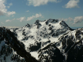
 North aspect of Brunswick from Gotha Peak in spring. |
Elevation | 1788 m (5866 ft) |
| Coordinates |
| |
| Quick Info | Brunswick Mountain, located north of The Lions and Mount Harvey, is the highest peak in the North Shore-Howe Sound area. The Howe Sound Crest Trail cuts across its western flank and a rough, steep side trail leads to the summit ridge. |