Lighthouse Park: Difference between revisions
imported>ScottN No edit summary |
imported>Champagne →Getting there: Added map with link to Google Maps |
||
| Line 2: | Line 2: | ||
==Getting there== | ==Getting there== | ||
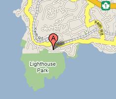
[[Image:Google_Map_Lighthouse_Park.JPG|300px|right|thumb|[http://maps.google.ca/maps?f=q&hl=en&q=LightHouse+park,+Vancouver,bc&ie=UTF8&z=13&ll=49.339888,-123.248577&spn=0.052346,0.117073&om=1 Local map] of Lighthouse park (from Google Maps).]] | |||
To get to Lighthouse Park for climbing one can take Translink buses to Marine Drive and Beacon Lane in West Van, which is really close. | To get to Lighthouse Park for climbing one can take Translink buses to Marine Drive and Beacon Lane in West Van, which is really close. | ||
| Line 10: | Line 10: | ||
This looks like a 90 minute one-way trip from UBC; costs $3 or free with a UPass. | This looks like a 90 minute one-way trip from UBC; costs $3 or free with a UPass. | ||
In June midweek, the 250 is running every 30 minutes in evening. | In June midweek, the 250 is running every 30 minutes in evening. | ||
==Rock Climbing== | ==Rock Climbing== | ||
Revision as of 08:29, 6 November 2006
Lighthouse park is located in West Vancouver and is the site of a lighthouse and numerous well marked hiking trails. There are a number of very nice view points overlooking the ocean. The views are very romantic so choose your climbing partner carfully and watch the sun set.
Getting there

To get to Lighthouse Park for climbing one can take Translink buses to Marine Drive and Beacon Lane in West Van, which is really close.
From UBC, take the 17 or 4 (or etc) downtown to Granville Stn. Then walk along Georgia and catch the 250 Horseshoe Bay (westbound). It's about a 35-minute ride, get off at Beacon Lane and walk in. Most of the bus drivers know lighthouse park so don't be shy just ask them to call out the stop.
This looks like a 90 minute one-way trip from UBC; costs $3 or free with a UPass. In June midweek, the 250 is running every 30 minutes in evening.
Rock Climbing
Tree climbing and bouldering are also possible within the park.
Juniper Point Rock Climbs
The climbs described below are for Juniper point. Follow the signs from the parking lot. The list starts at the north and works south.
Ancient Mariner: 5.6 Protection: Gear, TR Description: The left-most climb on the wall with a top anchor. Can get to the bottom by rapping off the bolts or walking down the left hand side. small to med sized gear (nothing bigger than a #2 BD Camalot)
Double Overhang: 5.10b Protection: TR Description: The route below the large tree. Ascned the overhang on its right side.
Orca: 5.11b Protection: TR Description: The face route in the center of the wall which starts on the lower shelf. Top anchor bolts on top.
Starfish: 5.10d Protection: TR Description: The main arete which starts on a face and moves up to an alcove and a seam above.
Big Pin: 5.8 Protection: Gear or TR Description: The short face route that follows the dyke on the east end of the wall below the big pin which as well as being useful for an anchor point can also be used for mooring freighters and your large expensive yaht.
There is one or two more climbs past this one that are accessed off another set of bolts. 5.8 and 5.10a???????