Navigation
This page is all about wilderness navigation for hiking, mountaineering and ski touring.
Maps
NTS 1:50,000 map series
Most recreationists in Canada use the NTS 1:50,000 mapsheet series. These maps are convenient scale that covers a large area but also shows sufficient detail.

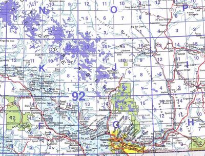
Each NTS map has a 3 part code. For example: 92 J/3 is the map for Brandywine Falls, the Brew Hut and Rainbow Mountain. The whole country is divided into a grid of 1:1,000,000 scale maps. Southwest BC is map 92 (9 = map index from each to west, 2=map index from north to south). All smaller maps that fit within map 92 are prefixed with the code 92. Each 1:1,000,000 map is divided up into 16 1:250,000 mapsheet that are index with a letter from A-P in a back and forth fashion. Then each 1:250,000 map is divided up into 16 1:50,000 mapsheets that is index with a number, again in a back and forth fashion. All this is very confusing, so the government has created index maps that show the relationships of the the smaller maps to the larger ones.
NTS maps come in 3 different forms. Usually each map is only available in one form, but sometimes you have a choice
- Tyvek maps are the best. They are printed on Tyvek which is waterproof and highly tear resistant. The only down side is it is very hard to write on them with a pen or pencil. Tyvek maps are a relatively new addition to the NTS map series. The number of maps available in Tyvek seems to be increasing, which is a good thing.
- Printed maps are pretty good. The image quality is the same as the Tyvek map series but the paper is less durable. These maps have been available since the beginning of time.
- Plotted maps are the worst. These maps have been printed on an inkjet printer by a 3rd party map printer and it shows. Image quality is poor and the paper is the same as on the old printed maps. Don't buy these maps if you don't have to.