Roe-Brew Trail
| Roe-Brew Trail | |
|---|---|
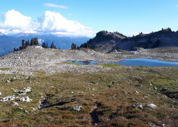
 Looking down the trail towards the upper lake in early September 2018. | |
| Length | 4.7km |
| Class | Class1 |
| Status | Clear |
| Access | R200 Branch |
| Destination | Brew Hut |
| Caretaker | Varsity Outdoor Club |
| Legal |
|
| GPS | |
| KML | |
| Maps | |

|
"The Faffening...coming soon to Slideshows near you" This article is a stub. Please help the VOC by expanding it. Thank you! |
Trailhead
By any access route, the final alpine section before reaching Brew Hut is an off trail hike (or ski). Whiteouts conditions are common above Brew Lake, making good navigation skills necessary to reach the hut. A map (92 J/3) and compass are essential to have along. For GPS waypoints along the various access routes, see the Brew waypoints page.
The following topographical map shows the Roe Creek access trail with logging roads current to October 2013:
This is the longest access route, but provides the safest way to access the hut in winter.
The Roe Creek Ski Route, a new route from Roe Creek FSR up to the Brew Lake has been marked and cleared for easier skiing. This route starts on a branch R-200 of Roe Creek FSR and wraps around the broad ridge running south from Mt. Brew on a bench, connecting with a meadow system just south of Brew Lake. From Brew Lake to the hut there are no flags or markers but navigation is straightforward in good weather. This route offers a mellow ski most of the way, and has very little exposure to avalanche slopes. It is is slightly longer than the historic route from Roe Creek, but is much less steep and does not necesitate crossing an avalanche slope. Also, this route can be descended from the hut all the way to Roe creek without putting on climbing skins.
The historic route from Roe Creek is to go up the Roe Creek logging road branch R-200 to it's end, and then climb up onto the top of the ridge that runs south from Mt. Brew. The ridge can be followed up to the alpine west of Brew Lake, and there are several places to drop off the east side of the ridge towards Brew Lake.
There is room for about 20 cars in a small lot just outside the locked gate and parking for Powder Mountain Catskiing 1.6 km from the highway. At one time PMC allowed parking inside their gated lot for a small number of non-motorized parties but as of February 2017 this practice has been discontinued. Contact info is above.
Summer Access
| 2WD | 4WDHC | |
|---|---|---|
| Parking Location | ##km up <Trail> @ elev. ###m | ##km up <Trail> @ elev. ###m |
| Nearest Town | Town (##.#km) | Town (##.#km) |
| Hiking distance | #.#km | #.#km |
| Elevation gain | #,###m (#,### ft) | #,###m (#,### ft) |
| Approximate time | #.# hours in / #.# hours out | #.# hours in / #.# hours out |
Winter Access
| 4WDHC | |
|---|---|
| Parking Location | ##km up <Trail> @ elev. ###m |
| Nearest Town | Town (##.#km) |
| Hiking distance | #.#km |
| Elevation gain | #,###m (#,### ft) |
| Approximate time | #.# hours in / #.# hours out |
Bulletins
- YYYY Month Day - Name
- Bulletin Content
- YYYY Month Day - Name
- Bulletin Content
Waypoints
The datum for all the waypoints below is NAD 27, to correspond with the NTS map of the area, 92 J/10.
| Km | UTM | Elevation | Description |
|---|---|---|---|
| 0.0 | |||
| 0.0 |