Roe-Brew Trail
| Roe-Brew Trail | |
|---|---|
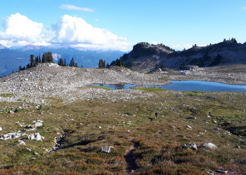
 Looking down the trail towards the upper lake in early September 2018. | |
| Length | 4.7km |
| Class | Class1 |
| Status | Clear |
| Access | R200 Branch |
| Destination | Brew Hut |
| Caretaker | Varsity Outdoor Club |
| Legal |
|
| GPS | |
| KML | |
| Maps | |

|
"The Faffening...coming soon to Slideshows near you" This article is a stub. Please help the VOC by expanding it. Thank you! |
The Roe-Brew route has been around for a while, but it wasn't until 2006 that it transitioned into a trail. In 2006 and 2007 many workhikes were carried out to brush out the route, put markers up and cut a better bed surface. The trail can be both hiked and skied.
The trail starts off the R200 Branch of the Roe Creek Road in the middle of a cut-block (circa. 2012). Look for the orange diamonds on a large stump about 50m up road from the 9.5km rock. The trail wraps around the broad ridge running south from Mt. Brew on a bench, connecting with a meadow system just south of Brew Lake. Along the bench the trail ducks in and out of patchy forests and the tail end of some talus slopes. At the meadow, the trail gradually turns left up towards Brew Lake.
From Brew Lake the trail turns West-North-West into the alpine and haphazardly travels up through thick heather and gentle boulder fields before turning North towards Upper Brew Lake. The trail passes the lake on the east side and continues north up towards the saddle of the bowl. At the top of the saddle, the trail turns east and the Hut will be visible a few hundred meters up on-top of a bouldery ridge. In summer, there will be a small glacial tarn below the ridge in between you and the Hut. This is the drinking water lake so fill up here before travelling the last 100m up to the Hut.
By any access route, the final alpine section before reaching Brew Hut is an off trail hike (or ski) and there are no flags or markers. In good weather, navigation is relatively straightforward, however, whiteouts conditions are common above Brew Lake and so good navigation skills can be necessary to reach the hut. A map (92 J/3) and compass are essential to have along.
Trailhead

Starting at Highway 99 travelling north, look for a sign on the right side of the road saying "Chance Creek FSR" or "Cat-ski Tours" or "Powder Mountain Cat-skiing" or something along those lines. There will be a left hand turn bay. If you see the Daisy Lake Dam, you've gone too far. Reset your odometer and immediately cross the Cheakamus River and two railway tracks. There is room for about 20 cars in a small lot just outside the locked gate and parking for Powder Mountain Catskiing 1.6 km from the highway. The road is plowed by PMC up to this point but not farther. At one time PMC allowed parking inside their gated lot for a small number of non-motorized parties but as of February 2017 this practice has been discontinued.
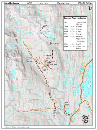
3.0km up the road turn right at the junction to leave the Chance Creek FSR and continue on the Roe Creek Road. At 5.9km you will cross Roe Creek. Low clearance 2WD vehicles can typically make it to this point and will park here. At 8.3km is the R200 branch which U-turns to the right. Some AWD and 2WD may make it here. Reset the odometer. At 0.9km stay right, 1.1km stay left, 1.3km stay right, 1.5km AWD park off to the right while 4WD continue left up a very steep road. Ample parking is at hundred meters up just before the trailhead.
The historic route from Roe Creek was to go up the Roe Creek logging road branch R-200 to it's end, and then climb up onto the top of the ridge that runs south from Mt. Brew. The ridge can be followed up to the alpine west of Brew Lake, and there are several places to drop off the east side of the ridge towards Brew Lake.
The following topographical map shows the Roe Creek access trail with logging roads current to October 2013:
Summer Access
| 2WD | 4WDHC | |
|---|---|---|
| Parking Location | ##km up <Trail> @ elev. ###m | ##km up <Trail> @ elev. ###m |
| Nearest Town | Town (##.#km) | Town (##.#km) |
| Hiking distance | #.#km | #.#km |
| Elevation gain | #,###m (#,### ft) | #,###m (#,### ft) |
| Approximate time | #.# hours in / #.# hours out | #.# hours in / #.# hours out |
Winter Access
| 4WDHC | |
|---|---|
| Parking Location | ##km up <Trail> @ elev. ###m |
| Nearest Town | Town (##.#km) |
| Hiking distance | #.#km |
| Elevation gain | #,###m (#,### ft) |
| Approximate time | #.# hours in / #.# hours out |
The route offers a mellow ski most of the way, and has very little exposure to avalanche slopes. This route can also be descended from the hut all the way to Roe creek without putting on climbing skins.
Bulletins
- YYYY Month Day - Name
- Bulletin Content
- YYYY Month Day - Name
- Bulletin Content
Waypoints
The datum for all the waypoints below is NAD 27, to correspond with the NTS map of the area, 92 J/10.
| Km | UTM | Elevation | Description |
|---|---|---|---|
| 0.0 | |||
| 0.0 |